Silverheels 100
Rocky Mountain bliss | my 64th ultramarathon
Pre Race
Sitting at home on the weekend I got a notification from
HPRS Facebook that their pre-race meeting was on for tomorrow night (Jul-06). I had somewhat been looking around to see if any races had been on for the last few weeks. Training solo and being alone for all of my pandemic miles I was itching to get back to a race atmosphere. I was ready for another 100 miler. I tuned into that Facebook Live broadcast, and after hearing Race Director John Lacroix go through the new race protocols and the new procedures of the race to help protect runner and volunteers alike I felt like this was a viable opportunity. I had mentioned the idea to my wife and she was encouraging me to go, as long as i was safe. Monday prior to this Facebook live pre-race meeting I had also talked to my work peer and confirmed if I would he would be able to take off an extended weekend. And just like that the conditions were in place for me to get away and run in the mountains. I entered my name on UltraSignup, paid my entry on Tuesday and informed work I would be off over the weekend, confirming my days off and coverage (I'm thankful to have flexibility like this). Just like that my weekend plans were set.
 |
Ready to hit the road. This was taken
Wednesday night as I packed. My
Victory Sportdesign bags carry all
my gear in my travels. |
My alarm buzzed nice and super early for 02:00 Thursday. I had packed and prepared my gear the night before. I kissed my wife goodbye and tried not to wake her fully. By 02:30 I had my coffee made and everything into my car and started my solo journey North West. 16.5 hours later and only a few stops for random bathroom breaks, 3 fuel stops, and 1 shakeout run stop in New Mexico, I had arrived in Fairplay, Colorado late into the afternoon. I got some food and then walked around the small town exploring the area on foot. Fairplay is a very small old mining mountain town that is home to the Burro Running National Championships each year. It is also the town famous for being where the cartoon South Park is based off of. Fairplay sits at the base of the mountains and is at just shy of 10,000' elevation.
 |
View of Fairplay, Colorado looking back toward the "South Park" area. Elevation 9,953'
|
The Day Before Race
After a nice dirtbag style night in my car (trunk/backseat) where i was able to get some decent sleep. I got up with the sunset in the chilly Rocky Mountain air - how I missed these cool temperatures! I relished the fact I was able to wear a hoodie first thing in the morning. I had gone to a local coffee stop and grabbed my essential for the day and then went out to meet up with the HPRS volunteers. They were organizing a hike and trail work day. I joined them for this and used it as a nice little way to enjoy the morning. I spent just over 5 hours helping out clearing, clipping, and brushing a local trail that was going to be used in the race. This event was done well as everyone kept their distance and also wore masks.
 |
HPRS trail work pre-race. This is on a section called "Jungle Hill". 2020-07-10
|
After my morning I decided to get a little shakeout run in and spend a tiny bit more time on my feet before taking rest before the big race. Looked up some local areas on the map and settled on a short drive to Hoosier Pass, not too far north from Fairplay at all. There was a small little parking lot there on the pass where a trailhead existed. I got out my running shoes and headed out on a short adventure. I've been "run streakin' " for a little bit now and always aim for minimum of 5 km (3.1 mi) per day, and therefore that was my goal. I headed down the trail and then climbed up and up shooting for about 2 mi out before I'd turn around. The beauty of the area and the pure exploration was exciting. I managed to keep my run under 4 miles although I definitely could of gone on for hours exploring. I did manage to sneak up to over 12,000' elevation as well (my 1-day acclimatization plan 😂)
 |
Just splashing in puddles like a little kid that I am at heart.
|
 |
Taking in the views and enjoying my short shakeout run. Hoosier Pass, near Breckenridge, CO.
|
After my run I went back to Fairplay to check it for the race in the evening bib pick up, dropped off my 2 drop bags, and then enjoyed a nice filling meal before enjoying the mountain sunset.
Race Day 2020-07-11
Another night dirtbaggin' it in my car I was up long before the sun. The race times were rolling starts in waves of 15 people at a time starting at 03:40. It was dark, it was chilly, but it was great to get up and be excited for a mountain adventure. I was set to start in the first wave, so at 03:40. I stayed in my car prepping the last minute stuff and ensuring i had everything in my
NATHAN hydration pack. To maintain my safety and my promise to my family i did not walk over to the start until 1 minute before go time after putting up my bluff wrap mask (this was also one of the requirements of the race at the start and aid stations). I looked down at my watch and saw 03:42 and the RD was counting down. Here we go...
We set off from Fairplay on a flat section out of town for a couple miles down a county road before ducking into the forest and back country. I was running with the lead 3 people for about 0.5 mi then they dropped back. We were not going particularly fast so I just kept my own pace and continued on in front solo. It was also a bonus as I was keeping my social distance bubble by doing so (😂).
 |
Silverheels Mine turn around. We had to obtain a bracelet here
to prove being there: once at 11.4 mi & then again at 91.9 mi.
Elevation here is listed at 12,070' |
After passing the
Alma water drop station the trail took us up into the mountains. The elevation gain started in a big way with a large climb from here all the way to
High Park and then ultimately to the high point on the course of Silverheels mine at 12,070'. By the time I arrived here it was 11.4 mi elapsed and already about 2,000' of gain.
I headed back down the mountain and eventually passed the runners whom started in the first wave. Everyone was in good spirits still and waved as we passed. We all had our bluffs up when we passed each other as was the request and race protocol. Once back down to High Park the course then went down over the other side of the pass of the mountain. I was still running in front. A long descent down into the valley past some old gold prospecting sites following the little creek. I rounded a corner and heard a rustling in the bushes to my left. Since I was alone in my thoughts it startled me a little and then I spotted the moose just hanging out eating some vegetation no more than 30 feet away from me.
 |
| Cow moose about 15 mi into the race. I got this picture once I waked away a few yards, hard to see in this picture, but it is there in the middle enjoying a morning snack. I was about 30 feet away initially when i spotted her on the side of the road. |
I continued on exploring the course and enjoying the mountains. There was a couple very small creek crossings and mix between singletrack, gravel roads, and some double wide jeep roads. Around mile 24 I was passed for the first time and lost the front running position. Another large section of climbing occurred just before the
Jungle Hill aid station. It was a long USA forest jeep road that climbed for what seemed like miles. Once at the top there a tiny bridge then was a 1.5 mi descent of singletrack down into the aid station - this may have been one of my favorite sections (coincidentally this was the area I was doing trail work the day before). A short stop here for some fruit and then I continued on to another out & back section where a water drop and hole punch (for verification) was. On the way back from this check point (
Crooked Creek) I passed a bunch more runners who were not that far behind as we were now nearing the 50 km mark into the race. I was still moving fairly strong at this point keeping a nice even pace, not too labored.
After the next aid station down in a little valley I could tell the course was taking us back up in elevation. I peered off in the distance and saw the climb that lay ahead beyond the alpine meadows were we trekking through. Somewhere around here another runner passed me and I dropped back into 3rd position. From the Trout Creek aid station I ascended upwards through these meadows and saw a good size mountain pass that I assumed we would be heading over. You always feel so small in the mountains and I just took in the views as I kept glancing up to my right thinking...."yup, we are going to be climbing up and over that". I think I was even telling myself I wish we would just go straight up and get this over with. Well I should've wished for something different because once at the true base of this small pass the trail went literally straight up for about 0.5 mi but gaining a bunch of elevation topping out at 11,400' or so.
 |
on top of pass between Trout Creek and Tarryall aid. At about 11,400' elevation.
|
Coming down the other side it was much more North American style traditional trails with switchbacks and zig zagging back down into the treeline. Not too far was
Tarryall aid which was the main aid and large crew station on the NE portion of the course. Runners hit this aid station a total of 3 times, and thus I elected to have one of my
Victory Sportdesign drop bags here. Just before
Tarryall the 3rd person caught me and we ran in to the aid together, and left up towards
Gold Dust together. Here she dropped me on the climb and thus I dropped back to 4th place. I attempted to catch on the downhill but did not push to much as I was trying not to blow out my quads since the race was still not even 40% complete at this point. A 4th runner passed me pushing me back to 5th before reaching the aid station.
 |
Heading back towards Gold Dust,
about 50 mi completed.
|
A large section of gravel country roads was the next portion of the course. Looping around from
Gold Dust through
Halfway Gulch and returning back to
Gold Dust,
Taryall aid stations. It was a long gradual climb up and around the initial portion of the loop but then it turned directions and was a ridiculously long gradual downhill. Again I tried to pace myself here to save my legs. I managed to pass by one of the runners moving back up into 4th position (he was having stomach issues, just before
Halfway Gulch). I kept it steady as I could. The biggest and most annoying part of this section was the dust from all of the vehicle traffic on the road. It was so hot and dry the dust just lingered. But man the views were great from up on this road. The road circled around another peak and headed back up towards
Gold Dust aid. I passed the female in front of me here as she was walking towards me (backward on the course). I asked her if everything was good, and she assured me it was but that she was dropping from blowing out her quads. I still not quite sure where she was self extracting since the aid station in front of us was the shortest way of course I thought. So arriving back through
Gold Dust and back to
Tarryall (second time), I was not back to 2nd place since 2 in front of me had dropped.
The large aid station of Tarryall was a relief site as it was very hot now in the middle of the afternoon and have completed 55.8 mi of the course. Now was a longer out & back section that took us out to Camp Como. It was a great section of trail that had some nice technical rocky terrain mixed in with singletrack winding through the woods. It was a great section of trail, I just wish I had more energy. About 2 miles from the turn around I passed the front runner which means he was about 4 miles in front of me (nearly an hour).
 |
| Rockier terrain on the trail to Camp Como turnaround aid station. |
All the way back to
Tarryall for the third and final time, I sat down here briefly for the first time and enjoyed a bit of food and nutrition before setting out on tackling the large climb back over the pass that brought us into this area of the course. Another runner came into the aid station not far behind me and was also sitting down for a break. I left before him and headed out trying to get to aid and over the pass before needing my headlamp from the impending night darkness that was coming. The grind was slow and long climb back up the pass, and it wasn't long before I was caught again. We worked together for a little bit but I could tell he had slightly more energy so I let him go ahead on the final portions of the pass ascent. At the top of the pass I had to take a bio break and stepped off into the woods. I used some leaves of sort that somehow was not the best choice as later on it caused a little irritating rash that bothered me for the rest of the run (this is the first time this has happened to me during a race). I did manage to keep it under control while running once I got to an aid station and used some of the best anti-friction lube there is:
Trail Toes.
After my bio break and then tip toeing down the straight down side of the pass I managed to get running decently again. But at this point there was another runner and his pacer who were "flying" and passed me with ease. Not too far later I actually caught the guy who had passed me about a mile back coming over the pass, but he hung on and so we ended up jut running together for the last half mile or so back down to the Trout Creek aid. We started chatting to keep each other company and distract ourselves as the darkness was nearly engulfing now.
 |
Early morning feelings.
|
We arrived into
Trout Creek and both sat down and got some hot ramen noodles soup here from the great volunteers. It appeared neither of us was trying to run away from each other at this point so now with headlamps on we headed out for the remaining 35 mi leaving together. Myself and Thomas, as I finally discovered his name, worked together for the next couple hours which made the time go by a lot faster than running solo. We got all the way to
Jungle Hill climb before he was now moving better than me on the climbs. I told Thomas to continue on and I would try and catch him back on the downhill section. But I never did catch him again. I was back on my solo trek running in 4th place with a marathon or so to go. The hours ticked by slowly and my usual early morning lows were catching up to me. I had the biggest longest climb ahead from
Poor Man Gulch up to
High Park and all the way to the high point of the
Silverheels Mine to obtain my second summit bracelet.
My feet were killing me and drastically slowing me down. My legs felt pretty good considering so really it was my sore tender feet that were my issue at this point. After the looooooong grind back up to the mine negotiating the near sunrise hours I finally started to feel awake again, opposed to the sleep walking pace the last couple hours were. Grabbed my second bracelet and then turned around headed back down the mountain. It was a long half marathon all the way to the finish with 80-90% of it being downhill. It was still slow going as the pain of the constant downhill started to creep into my quads, but still mainly my feet. Near the very final "aid" stop of Alma, which is actually just a water drop, I got confused and was actually going bakwars on a section repeating a portion i just did. Here the leading female and her pacer met me and asked me where i was going. I double checked my gps and realized that I doubled back on a trail i was looping around on. Luckily it was only maybe a 0.25 - 0.5 mi of extra mileage, but who knows how long before i would have noticed if I did not meet them there. I tried to keep up with these ladies as I was now knocked down to 5th overall. I kept up for a good while all the way to the country gravel road section with 4 mi to go. My feet were causing me to shuffle a lot slower than I wanted to go and there was no way for me to keep up. I settled into my own pace and kept pushing forward towards Fairplay.
Finally of what seemed like forever on that last gravel stretch, the town of Fairplay came back into view. Like one does in the end of long endurance runs i was walking for a bit until I turned the corner and the South Park track was within view. I then resumed my ultra shuffle and "ran" onto the track making the 3/4 loop around and under the arch for the finish! 5th overall and done in under 30 hours this was my longest 100 mile finish yet. I had a goal of 24 hours initially, but i did not know if that was possible. I know the altitude had a little to do with it, but honestly for the most part my feet are what did me in. The altitude does not affect me in terms of headaches or altitude sickness that some people seem to experience, I guess I am lucky that way. This was my 64th ultramarathon.
 |
Start/Finish arch with Mt. Silverheels in the background. Thank you HPRS.
|

I sat down in the field and took off my shoes to reveal large heel blood blisters on both feet. I got my chair and put my feet up for awhile trying to relax and nap a bit as I watched the first few 50 milers whom started to trickle in within the next couple hours. I got in a bunch of fluids and a few snacks. Before some afternoon showers rolled in I packed up my car and started out on my next portion of my endurance weekend: the 16.5 hour return drive back to Texas. There was a lot of stopping for naps and a few walk breaks to try and keep legs loose as possible, while keeping my feet swelling down. I arrived back in Sugar Land, TX later afternoon Monday returning to elevation of 85'. I went straight to a quick testing facility and got my blood drawn to get a COVID-19 test - which turned out negative. I did this for peace of mind returning to my family. I then did get in a recovery run that Monday night keeping my #runstreak alive which is now nearing 100 days. Time to rest up and continue onto the next adventure whenever that maybe.
Course Details
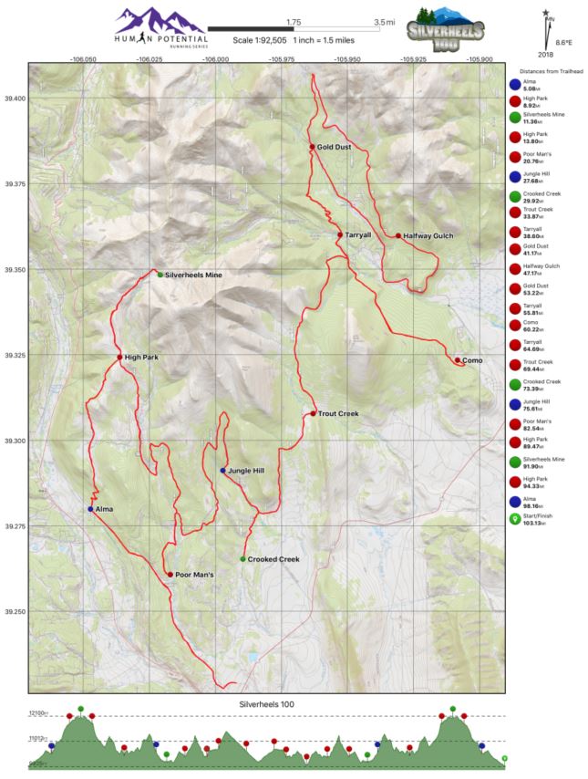
This was a great course. Essentially a long lollipop style course with a couple out & backs thrown in there. HPRS shared the detailed map, aid stations, and eve the .gpx course prior to the event for everyone. The course was very well marked (but not over marked 👍). Silverheels is a very tough challenge for everyone since it is known as the 2nd highest 100 miler within North America, behind only Hardrock 100. Silverheels comes in at an average elevation of 10,813' and let me tell you that it feels that way especially on the second half of the run (of course I am coming from sea level).
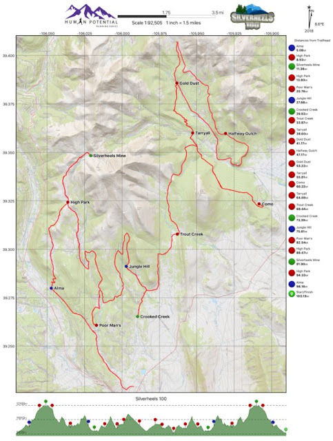 |
Detailed map and elevation profile provided by HPRS. Available on their website.
|
Nutrition
I stuck with mostly BASE Performance hydration mix and water (1 bottle of each). I supplement this with fit for the most part all the way up until about 70 mi mark. From there I started using GU Roctane gels one every 45 minutes or so to keep my energy up for the last quarter of the race (I think i went through about 6 of them total). I also downed Coca Cola every aid station for that quick sugar and caffeine hit. I think i also sat down and ate ramen noodles 2 separate times for the broth and warm fluids during the night hours.
Results & Data
Mileage: 105.70 mi (170.11 km)
Elevation Gain: 14,914' (4,554 m)
Total Time: 29:47:41
Place: 5th overall (4th male)
 |
Silverheels 100 buckle and (x2) Silverheels mine summit bands
|
Thanks
- A big shout out to all my supporters and sponsors for this year - check out my Friends page.
- Human Potential Running Series (John Lacroix) for putting on this event and taking the new race protocols and social distancing seriously to make this event happen. I did feel quite safe out there.
- The volunteers! As always fellow ultrarunners and non-runners alike that help make these events happen deserve the majority of the credit. Thank you for assisting us runners and aiding us through the night on the mountain.
#staysafe everyone and remember to continue to social distance and follow your local guidelines. I know that some people may think me travelling at this time is not the best idea, and well I may tend to agree I put in all the mitigation measures possible to keep myself and my family safe. In the end I felt like I did everything I could. There is still a lot of people out there not wearing masks.
----- ----- ----- ----- -----
Thank you for following along .
This was ultramarathon #064 for me, and 16th 100 mile (or longer). Next up:
(i) Blazing 7s 100 mi Virtual Run (date: t.b.d. before Aug),
(ii) completing my #EverySingleStreet Sugar Land project
(iii)
Trans-Texas Virtual Run 879 mi