Showing posts with label Colorado. Show all posts

Saturday, August 15, 2026

Collegiate Mountain Fun

Second Time Around in the Collegiate Mountains

51st 100-Miler(+) | 133rd Ultramarathon | 2nd HiLo

Colorado bound.
Felt pretty lucky to get into High Lonesome for a second time since the lottery is a true 50/50 split, meaning I was only 1 of 125 males to get into the race of the hundreds that applied. Blessed for the opportunity and so could not turn down another run in the Collegiates.

I had to interrupt our bi-annual California family trip, yet again, and make a side quest out to Colorado to get some true mountain time in. I mean yes, I really had to. As the saying goes the Mountains are calling and I must go. It rings true to me as I do love the mountain scene! Leaving from the West Coast I hopped into a rental car (a Honda Civic) and started my way inland towards the Rocky Mountains. After the 15-hour drive time I arrived in Buena Vista, Colorado the evening before race check-in and race meeting. I got some rest and then decided to make the most of my trip into the Collegiate Mountains area and drove out to Denny Creek Trailhead which was the start of the Mount Yale summit trail. I spent a nice 3.5 hours hike up and jog down to bag my first 14er. It was an awesome day just enjoying the mountains and seasoning my quads for the following day(s). A nice little creek dip at the trailhead near my parked car to cool of my legs, and then I headed back into town and complete my race check-in process. After the race meeting, I finally found a local restaurant that was not too crazy compared to the rest in the overrun town (due to the race crowds). I sat down for large burger, fries, and nice cold NA Beer then it was off to the cozy seat of my rental for some rest.

Pre-race portrait
Photo: Mile90 Photography | Rick Mayo

The Start
Photo: Mile90 Photography | Kristi Mayo

Awake bright and early at 04:30 to drive out to the start line and get my parking spot nice and close. Volunteers were there assisting already parking cars lining them up nice and neat within the vastness of the open ranch field. I took a couple minutes to enjoy my cold brew coffee (I had bought the night before in preparedness) before heading over for race check-in which included a full mandatory gear check before being allowed to start. I was ready. The sun was slowly bringing a glimpse of light over the silhouettes of the Rockies to the East. As the clock ticked close to 06:00 there was a larger and larger buzz of people and crew gathering and running back and forth. The chute was lined with runners and all the supporters formed an outgoing chute of cheering and filming spectators. We all took off as the top of the hour arrived and the adventure began.

The first 2.5Mi was on pavement down from the ranch, which sat up on a plateau down through the Chalk Creek area and hot springs. Emerging past the housing you hopped onto a gravel dirt forest road for another 1Mi until we arrived at the Colorado Trail (CT) where the ascending began. Having done this course before I recalled the initial looooong climb, however I was mistaken on where it was. I kept expecting to come around the corner and recognize the climb I had recalled in my mind, but it never showed up (at least not yet). I just cruised in a nice train of about 7 of us runners as I kept to the back and paced off their effort which was a nice easy start to the day. Just shade after 7 Miles we arrived into Raspberry Gulch, which was the first aid station. Lots of friendly volunteers there with a high vibe still. I topped up water and then continued on.

Photo: Mile90 Photography | Rick Mayo

Not too fat after leaving the aid station I came to some familiar trail that I knew was the beginning of that long 7 Mi climb I had been recollecting in my mind. "I knew it was at the start of the race!" I noted to myself. This was the long grind up Antero Pass, which we passed just below the 14er summit of Antero and crested above 13,100' ourselves. This was the high point of the race and provided great views up there. Crossing over the pass was followed by a long descent broken up by the second aid station. It was a real quad crusher to continue for about 10km all the way down to this next low point. 

Cresting Antero Pass (~14Mi). Photo: Mile90 Photography | Jordan Chapell

The next section was the iconic cresting of Law's Pass and down Popular Gulch Trail to the Cottonwood road and aid station. This is the only out & back section of the course, so it was ~3Mi up followed by 3Mi down. You then got checked in at the aid station and turned around to do this 6Mi again back to the main HiLo loop. This was the time in the race I got to experience a bit of adverse weather. The clouds came in early and slight thunderstorms were approaching. It was still warm out, so the combination of approaching rain and the heat caused humidity to rise. As I got higher up on the Law's Pass it started to rain as the clouds surrounded the area. It was a nice refreshing light cooling rain mist at first as I crested up and over the first time. The rain picked up a little as I ran down towards the Cottonwood aid station at the bottom. Since it was the only out & back I started passing all the faster leaders on their way back again. Arriving at the bottom (i.e. the Cottonwood AS) it was really raining now. I got some fluids and fuel there underneath the aid station tents attempting to stay dry. Before leaving was a mandatory Divide gear check and so I had to unpack and show everything before leaving. Since I was already doing this, I put on my rabbit Treeline rain jacket before heading out on the trail. The rain continued heavier as I climbed back up Law's Pass, again this time from the backside. The trail even began to have slightly running water in some of the rutted-out spots. By the time I got back to crossing the Pass it was somewhat clear at the top again. I had climbed through the cloud, because I could see from the top the other side of the mountain was clouded in below. 

Descending from Law's Pass (~35Mi). The clouds are fully parted here just barley below the Pass.
Photo: Mile90 Photography | Kristi Mayo

2 Moose were hanging around Tin Cup AS.
Photo: Mile90 Photography | Kristi Mayo
It was now just over 38Mi into the run as I arrived back at St. Elmo aid station and was about rejoined the main HiLo loop. Here I even got to visit with my friend Leo Fung whom was there volunteering as a Rescue Medic helping out at the aid station. We chatted and caught up for a bit as I sat down and emptied my shoes and took care of my gear, stowing my rain jacket safely back in my race vest. Just a  couple miles down the trail to Tin Cup aid station where I got to spot a coupe moose just hanging out. From there it was onto arguably some of the most scenic sections of the course on the Continental Divide Trail (CDT).

Entering the Continental Divide Trail (CDT).


Full rainbow. Photo: Mile90 Photography | Jordan Chapell

The CDT took us into some of the most remote areas of the course which provided amazing views and scenery of the surrounding mountains. Here in these longer remote sections then night came after passing through Hancock (which marks the halfway point).

Up and over Chalk Creek Pass.
A sharp 3Mi climb as night fall arrived up pass Hancock Lake was one of these climbs I remembered from my prior run here. It seemed to go on forever since you can see the string of headlights above you without seeing the top of Chalk Creek Pass in the darkness. 

The night provided nice cool temperatures but never really got too cold even at the higher Colorado elevations. A brief stop at Lost Wonder Hut was a nice break as I was passing and being passed by fellow runners in the nighttime hours. A long trek to the last big landmark on the course, Monarch Pass, was next on the route. Passing through the high ridgeline at night I passed the makeshift aid station (Purgatory) in the middle of this section at the leading edge of the Monarch Ski Area. From there following the Ski Resort roads and trails lead me to the large main aid station at Monarch Pass right on Highway US-50. This had to be the biggest aid station of the course, easily accessible so the vibe was upbeat even for the wee hours of the night, errrr morning now at this point in my race. 70 Miles now complete. Only 30% of the race remain which is the equivalent to basically a 50 km distance left between me and the finish line. The sleepies were trying to catch me since I was entering the witching hour, as some call it, which is the point of circadian rhythm associated with highest Melatonin level and the lower Cortisol levels.

Managing through those last couple hours of night and into the first hour or so of sun up was the hardest part for me this go around. I really fought to stay awake and keep moving efficiently. My paced had slowed considerably, but at least my direction was...well...forward. After the sun crested over the mountains the heat of the day really started rising here on the second day. It was already warmer than the mid 60s from the fist day. In fact, I think overall it got up into the high 80s or perhaps even 90s (ambient wise) by the time the final cutoff rolled around. This made it challenging for the majority of people as the mid-pack in this race is between those 28-34 hour times, and of course even perhaps more grueling for the very back of the packers whom put up with everything, having the most grit of all, and coming in for that sub 37 hour official cutoffs.

Second Day. Mile90 Photography | Jordan Chapell
Passing Blanks Cabin was a notable point as I am knowledge of this area just from the fame of being one of the end point for Nolan's 14. Besides it also signaled that there was only 1 more aid station that closed the HiLo loop and then it was just the 7.3Mi trek back to the ranch for the finish. Lots of people were out here at Blanks as the morning crews and volunteers were all awake and cheering people on now. My tiredness was left behind me somewhere on the mountain now that I was well into the second day. Back at Raseberry for the second and final time I ran into Leo Fung again, this time in his morning volunteering shift there helping runners staying cool and hydrated in the now scorching Rocky Mountain sunshine. He even found me a non-advertised (as he called it) flavored popsicle. It was magical and cold!

Glancing at my watch I knew there was now well under 10 Miles to go and so I knew it was just a couple more hours of grinding through the forest back towards the Chalk Creek area and into the finish line back on the ranch. I kept my running pace up pretty good as I was chasing a female runner and her pacer for a good part of this section trying to keep pace. I had given up the fact on my goal times this go around and was now just focused on my ultimate goal of finishing and getting that buckle. 

The final climb up Rodeo Road.
Side Note my original goals were as follows. I was aiming for:

  • A= sub-28 hr
  • B= sub-30 hr
  • C= sub-31:54 (prior time)
  • D= finish/buckle!. 
I feel it is always good to have layered goals I order to keep yourself not only honest, but motivated when your first one slips away.

Running up that last hill coming out of the Chalk Creek hot springs area seemed like a daunting task at the time, but in reality it was only a couple hundred feet and less than 1 Mile to the finish. However, being the very end of the race, on the pavement with cars passing by, and in the heat of the day it was not the most pleasant way to "run it in" but heh that is part of the deal here.

My 2nd HiLo finish.
Photo: Mile90 Photography | Kristi Mayo

Finish Line vibes for my 51st 100+ Miler overall!
Photo: Mile90 Photography | Kristi Mayo

Results & Stats

Photo: Mountain Outpost Livestream (via YouTube)
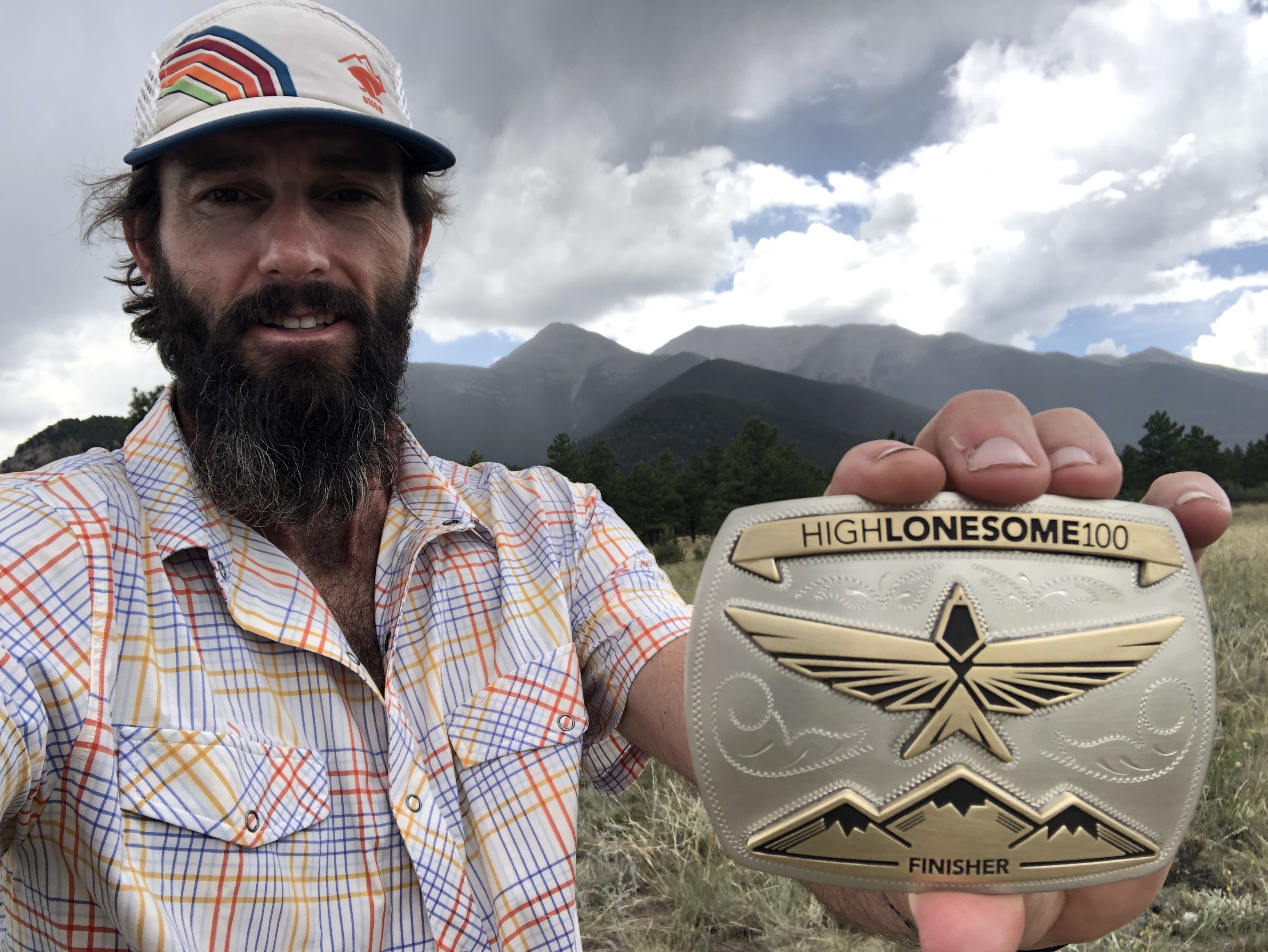
 LAWS Whiskey House HiLo Special Edition Bourdon & Finisher 2X Buckle.
There is only one way to earn both of these!

Gear Used

  • [mandatory gear] Lighting setup - kogalla RA Adventure Light (waistlamp) & Black Diamond Storm-R (headlamp)
  • [mandatory gear] Jacket- rabbit Treeline rain jacket (rabbitELITEtrail team edition)
  • SS Shirt - High Country rabbit trail
  • Arm Sleeves - rabbit UPF
  • Ultrarunning sock tan!
    Shorts - rabbit 5" Shredders 2-in-1 trail
  • Headwear - rabbit (Boco) RADrabbit team kit
  • [mandatory Divide gear] LS Shirt - rabbit Layer One (rabbitELITEtrail team kit)
  • [mandatory Divide gear] Pants - rabbit Runners (rabbitELITEtrail team edition)
  • [mandatory Divide gear] Headwear - rabbit beanie
  • Eyewear - Tifosi Optics
  • Shoes - ASCIS SuperBlaze
  • Socks - injinji
  • Hydration - UltraSpire Traverse Hydration Pack 20L with x2 20oz soft flasks & Katadyn BeFree™ Water Filteration System™ (0.6L soft flask).
  • Watch (with GPX track of course) - Garmin fēnix® 6X - Pro Solar Edition
  • Cell Phone - apple iPhone 16e (also with Gaia GPS app)
  • [mandatory gear] Emergency Bivy - SOL emergency bivy
  • Post Race- rabbit RADrabbit hoodie & rabbit EZ slides
Finish Line 2X buckle photo with RD (Caleb Efta).

Hanging out with friend Dena Carr at the finish line after getting our LAWS Whiskey.
Photo: Frank Carr.

----- ----- ----- ----- -----
Thanks for reading.
Here is a throwback to my first HiLo race report in 2022 if interested.
What is Next? 
It is Habanero season! 
(NOTE: I vowed to never ever go do again. However, the brand new 135 buckle looks very-very-very cool. As someone who considers buckle prospecting a hobby I just could not stay away, even if this is a stupid (in a good way) race concept.) 

Sunday, June 25, 2023

Ring the Springs 100Mi

Ring the Springs

A Colorado Adventure | Ultramarathon #104

I had been scheduled to run Angeles Crest 100 at the end of July after some lottery luck, but due to some unfortunate road closures and lack of access to the course the 2023 AC100 edition had to be cancelled. So I made a pivot and hopped into a different 100 Miler: Rings the Springs. Another ultramarathon and anther late signup in typical #UltraRunningDad fashion. I am always eager and ready to take on 100 Miles so it did not deter me, in fact I was looking forward to a new adventure in Colorado Springs.

Manitou Incline shakeout.
Arriving super early on Friday morning prior to packet pickup I made a quick little exploration shakeout run up the Manitou Incline as I had not been to this area prior and so I had to do this iconic climb. I then picked up my bib #3 at the runner check-in and enjoyed some food and the sights of Colorado Springs with a wander around Garden of the Gods abiding my time.

An early wake-up alarm from my phone jarred me into reality as sat up from a sleep in my passenger seat of my “dirt-bag” style car camp. I drove my way over to Rock Ledge Ranch and got my morning calories in: 2 apple turnovers and a cold Monster coffee beverage (a true healthy breakfast). There was a nice Rocky Mountain chill in the air, as the temperature was still in the 40s. I stayed in my car getting ready and warm until the 15 minute warning when Jamil Coury (Aravaipa RD) gave out the race briefing. I had everything packed into my vest and was ready to go. 

At 05:00 we headed off on our Colorado adventure. The first portion winded briefly through the edge of Garden of the Gods and then into the city of Colorado Springs for about 4 miles paralleling the highway to the south end of Colorado Springs before we checked in at America the Beautiful aid and then crossed under the road and headed into the North Cheyenne Canon and Pike National Forest section which created a large (~55Mi-ish) lollipop loop. The sun was warming the air as we began to climb up into the mountain terrain. The overall section from the edge of the city to the peak of the course was essentially a non-stop uphill grind all the way up to the summit of Mount Rosa. I was in the front pack of runners which we had spread out pretty well by now, only seeing a couple runners ahead of me but mostly running by myself sticking with my own rhythm. I was simply out there just loving the Colorado trail atmosphere. There was a short 1.0Mi out & back portion to the actual summit of Mount Rosa (11,506 ft+). A couple of small patches of snow and ice remained in the shadows on this summiting section. This allowed me to see where I sat in the race at this point although it was still super early relatively speaking. I believe I was 4th, maybe 5th, overall to the summit and then past a few more runners on the way back down before the turn rejoining the course loop.

From here the net downhill portion of the course took over as it was a non-stop decline for miles upon miles coming around the other side of Mount Rosa and eventually back around to the Gold Camp aid station. This was a tough section for someone not used to quad pounding descents. Luckily it was not always super steep, but it was relentless, which made it very challenging for a flat-lander. Arriving back at Gold Camp was a great moral boost as crews and spectators were gathered waiting and cheering runners in. A couple swigs of coke and refills of my bottles I continued back down the road descending on the same initial portion of the course back towards Colorado Springs. There was a passing thunder storm that I was trying to outrun, but eventually it engulfed me with a pounding of 10 minutes or so of hail followed by a downpouring of rain. I brought out my rabbit Treeline jacket and just kept moving downhill trying to outrun the storm. As I got lower and lower in elevation it seemed to let up slightly. Soon the clouds parted and it was over just as fast as it had started.

A long descent back down we crossed back under the main road and running back into the initial aid station (America the Beautiful) which was now aid at mile 57.3. Mentally it was great to reach nearly 100 km point and be back into urban area. I was now looking forward to my tour of Colorado Springs up close. Leaving America the Beautiful Park we headed along the water following a nice flat crushed-rock multiuse trail (the Pikes Peak Greenway) for about 6 Mi (10 km). Honestly I this point I was kind of dreading the remaining miles on the course because I just kind of assumed that the course might be on this greenway. This is my fault by design as I don’t always read full course description and details because I like the excitement of not knowing precisely what lies ahead. 

Ring the Springs 100 Mi course map.

Ring the Springs elevation profile. High Point: Mount Rosa: 11,506 ft+.

Eventually the course veered off the main greenway and followed the Templeton Gap Trail. After nearly 3 miles down this trail on more of a sidewalk, we dove into Palmer Park and utilized a lot of singletrack. This was a pleasant, welcomed surprise. The only issue was there was about a mile of horrible slippery clay section of trail that had not drained from the prior rain and thus it was super slick and the type of mud that just builds up on your shoes. The result was a slow slog through this section. Eventually the trail conditions became slightly rockier again which enables a little faster movement. The lead female runner (Rachel Hawkins) caught me from behind and I tagged onto her pace using the motivation to keep moving. After a few miles together, we reached the far end of Palmer Park where the aid station was set up. Here I got some excellent warm broth and then got my headlamp and kogalla adventure light out ready for the impending darkness that was now engulfing the city landscape.

Photo: Rachel Jump Photography

I took off from Palmer aid, headed on my journey, as Rachel was still there with her crew. The next section was a sunset singletrack dance around the Templeton Trail which was a technical, rocky, and very twisty trail on a ridge above the park open space below. There was an event Aravaipa camera crewperson taking some video on this trail and caught up and followed me briefly in the low light setting (I hope to see that video clip eventually). The sun inevitably gave into to the horizon and I had to switch on my kogalla waistlamp to lead me. 

The next portion of the trail continued on trails winding through the Austin Bluffs Open Space. There was a few wrong turns I made due to some missing flagging (vandalism? hooliganism?). There was a second runner whom caught up to me at this point as well and we kept leap frogging each other and helping each other out following my gpx on my Garmin watch coordinating with the tracking on his phone. As mentioned we did make a few turns by mistake as some of the junctions weren’t marked correctly (not blaming Aravaipa at all since the entire course was well marked, I assume this was done by random). The small setbacks caused a little frustration but eventually we worked our way over to the next aid station: Pulpit Rock. A quick refuel and food intake here and I was off again trying to keep my forward momentum going to take me towards a sub-24 finish – I knew I was starting to loose ground on my goal. The next city park was a quick tour of Ute Valley Park where the second to last aid station was here.

The end was now within sight - somewhat – only 12 Mi to go. Leaving Ute aid I knew I just had to keep moving well and limit my walking time in order to keep pushing the 24 hour time goal. I was running in 3rd overall at this point with a couple people behind me not too far. This brief section of the course was adjacent to the roads bringing us back around the final portion of the city loop on the top (North) side of the Garden of the Gods. Coming through a neighborhood and then following a sharp turn up a park maintenance road headed towards the final aid station. This road was straight up. A 1.0 Mi section which gained a full 800 ft+ elevation without any let up, just a steady grade climb. This was the final climb of the course but it was a doozy! I power hiked this portion fairly well and was happy to see the lights on the aid station tent at the top signaling only 5.5 Mi to go.

I sat down and chatted with the volunteers as I enjoyed some Coca-Cola. I refilled my bottles and then to my surprise another headlamp came up the climb approaching the aid station. It was Walter Handloser (infamous for this running the record of 100s in a calendar year). I muttered to myself (“crap”) as now there was 2 of us there with less than 10km to go to duke it out for the final podium spot. Walter was in and out of the aid after a bottle fill and nothing else, he took off down the road. I composed myself at this point and followed him trying to keep up. He was moving very well and kept a good pace running done the endless declining Rampart Range Rd.. Soon Walter’s headlamp disappeared in front of me as his legs carried him faster downhill that I could go at this point 23.5 hours into the run. A couple of miles later we crossed off the road and into some singletrack trails within the Garden of the Gods Park itself. The sun was also starting to provide early light at this point signaling the start of the 2nd day which coincided with the 24 hour mark (more or less). I tried to keep motivated and stay in pursuit of Walter but I never did catch sight of him again. The last portion of the trail we rejoined the trail where we began the day prior right at the edge of Rock Ledge Ranch and followed the flags into the finishing chute under the Aravaipa banner. 24 Hours 44 minutes I had completed Ring the Springs and earned myself another ultramarathon finish.

I was presented with a buckle and had a few minutes to chat and catch up with Walter at the finishing area. There was only a couple of volunteers there and the chill of the morning was already overtaking me now that I had stopped moving. I got myself a warm coffee from the aid and headed over to my car to get into dry clothing and get warm. My adventure in Colorado was a success having achieved my 32nd 100 Miler (or more) finish. Now it was time to travel back home to Texas…after a quick nap.


Results

4th overall | 24:44:05 | 101.34 Mi (163.09 km) | 14,219 ft+ (4,334 m+)

STRAVA: Ring the Springs 100Mi (4th overall), Colorado Springs, CO | Run | Strava

UltraSignUp: 2023 Ring the Springs 100 Miler - Results (ultrasignup.com)

My 104th ultramarathon run.

My 32nd 100 Mi (or more) completed.

#BuckleUp


Gear List

Shirt(s): rabbit SS rabbitELITEtrail team kit

LS shirt(s): rabbit LS UPF 30 Deflector (hood)

Sleeves: rabbit

Shorts: rabbit 5" shredders 2-in-1

Jacket(s): rabbit Treeline

Shoes: Altra Olypmpus 4.0

Socks: Dry Max

Headwear: rabbit (BOCO) rabbitELITEtrail cap

Gloves: rabbit (BOCO)

Watch: Garmin fēnix® 6X - Pro Solar Edition

Lighting: kogalla RA Adventure Light (waistlamp) & NATHAN Halo Fire (headlamp)

Hydration: NATHAN Pinnacle 12 L race vest

Anti Friction lube: Trail Toes

Gear Bags: Victory Sportdesign

----- ----- ----- ----- -----

Tuesday, August 2, 2022

Gettin High

Gettin' High in Colorado

High Lonesome 100 | Ultramarathon #089

Pre-race Portrait: Mile90 Photography (Rick & Kristi Mayo)

Photo: Mile90 Photography (Rick & Kristi Mayo)


Preparation

July is an interesting month in our household. My wife has always used this opportunity to take the school summer break and head back to her home for the summer holidays and partake in her family reunion each year on the California coast. At year with the pandemic, I took the opportunity to work remotely and go with my family out to California. Yet again, 2022 presented a similar opportunity. With the flexibility of my current job role and the blessing of my awesome boss I was able to go with my entire family again for a summer getaway. With the draw of the oceanfront only 3 miles from the doorstep and 3,000’ mountains literally out their backdoor my in-laws house always has had a nice draw to me as an ultrarunner. (My wife was lucky to grow up in such a scenic portion of California).

In the middle of June we packed the van full of our luggage (along with my own storage of running gear and a few pairs of shoes) and headed west towards the Pacific Ocean. I packed in a lot of vert and mountain running in Santa Barbara, as I now know those trails very well from all our visits over the past decade. I had to take advantage of my last week or so of true training before my taper would begin for High Lonesome. This meant I focused on lots of hiking and running downhills to “season my quads” as they say.

A bonus week of training popped up when we decided to go to my in-laws cabin up in northern California Sierras (Arnold, CA) for a week. While still working remotely I was able to live, run, and sleep at ~5,000 ft elevation which was a nice little intermediate step towards heading to CO at the end of July. I even drove up to 9,000’ one day at Ebbett’s Pass on the PCT (Pacific Crest Trail) and just enjoyed the afternoon up higher. I used this week as my last training taking it easy and just trying to let my body get used to some altitude. 

Loading up my rental Kia Soul with my Victory Sportdesign bags.
Photo: Katie Meding
Back to Santa Barbara for a week and then I was off to Colorado for HiLo. I rented a car and decided to drive out to avoid the clusters of airport travelling with all the delays and cancellation that have been occurring. I just wanted to be sure I would get to the race logistically that was within my own control. Secondly the car rental was basically the same price as a roundtrip ticket, and that is before transportation once I landed. I don’t mind driving on long trips so the 15 hours of driving was not a deterrent. Wednesday of race week I set off East through Los Angeles then into Nevada, briefly across the corner of Arizona, across Utah, and finally into the heart of the Rockies within Colorado. The trip took me about 20 hours as I stopped and had a nice nap during the wee hours of the night. This meant I was able to enjoy the day adjusting and walking around Buena Vista, CO before the packet pickup and pre-race meeting. A nice coffee stroll along the river enjoying the views followed by a small lunch run around the hills above the river overlooking BV (sidenote: I recalled these trails from the start of Trans Rockies Run back in 2019). A small lunch and nap in my car before heading to the high school for packet pickup. I had to present my Colorado CORSAR card and also bring my shoes to wash (i.e. the Toad Bath).

All the nearly 150 runners, the pacers, and their crews were gathered into the high school gym as we listened to the race briefing. All the details and traditional messages were given out. After the meeting everyone piled out of the gymnasium and headed for their respective quarters for the night. For me this meant driving out to the start/finish line just outside of town and car camping in my little rented Kia Soul. True 100 Mile mountain ultras require dirtbag camping to have the true experience in my opinion.


The Race

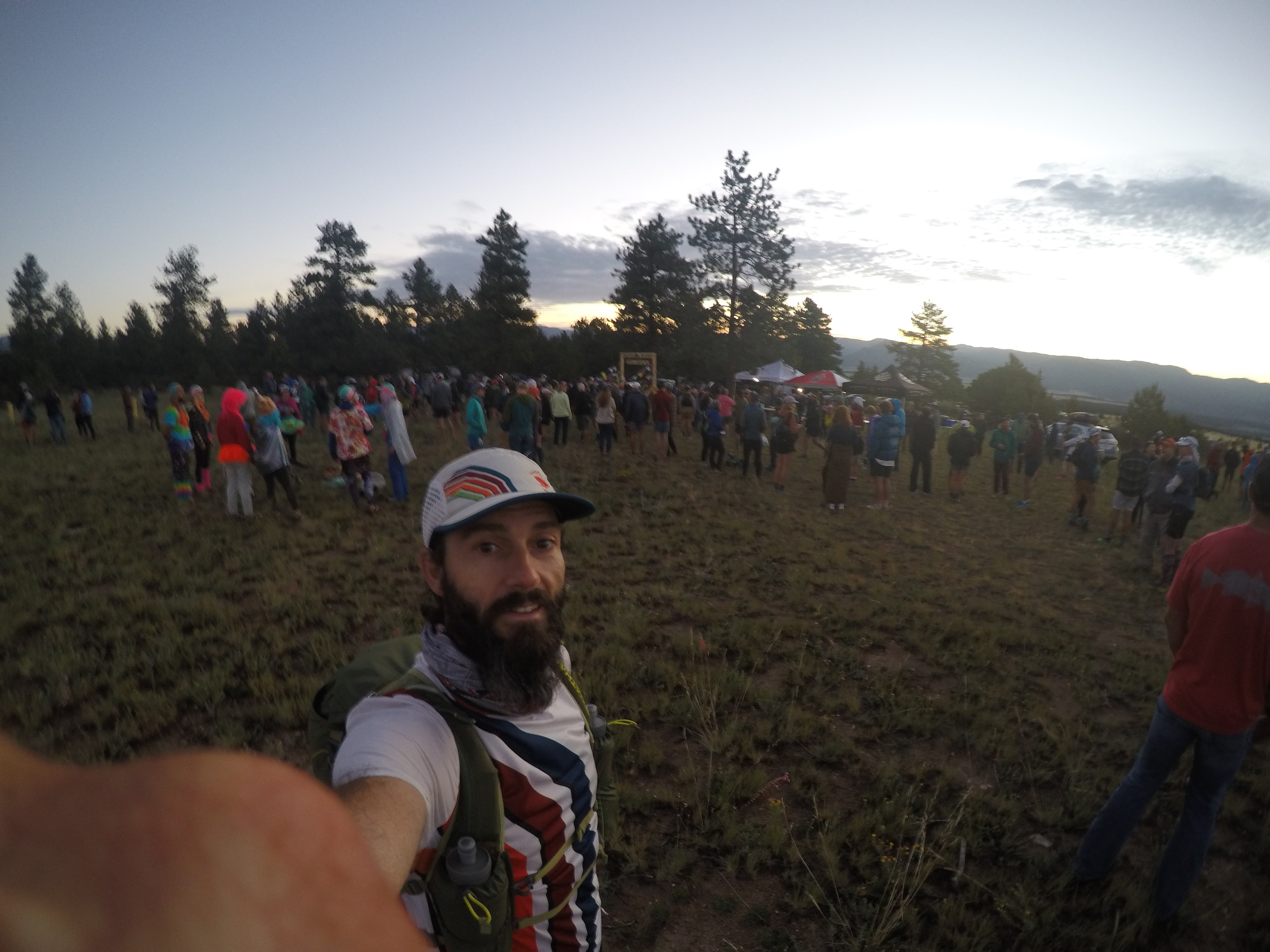
Start Area. Pre-race gathering at sunrise.

The morning was a nice crisp fresh mountain air despite being a bit chilly. There was not a cloud in the sky from what I could see and so we knew the morning chill would not last long at all. The start arch was in a large open field just a few miles south of Buena Vista. Runner check-in for the morning consisted of a mandatory gear check (for the required “basic gear”) before being allowed to line up in the chute. A quick photograph from Mile90 Photography under the starting arch and I was ready to go. A 06:00 start coincided with the sunrise slowly creeping up over the mountain range to the East. The first 2 miles of the race was down the paved county road and into a small dispersion of houses in the bottom of the valley of Mount Princeton Hot Springs. Another 1.5 miles on some gravel and we got to the CT (Colorado Trail) junction where we hopped onto singletrack and started heading up the mountain into the San Isabel National Forest. I settled into a smaller congo line of sorts following a group varying between 6-10 runners. The time flew by as it usually does in the first miles of a race due to the excitement and joy of the ultra event itself. Raspberry aid station was the first stop after an hour and a bit of running, 7.3 Mi into the journey. A refill of water and a piece of watermelon then I was off again.

Leaving the Raspberry aid station there was a short flat section through the forest and then the climbing began. I looked down at my Garmin fēnix® 6X to see what was ahead of me. I had the .gpx of the course preloaded and so I was using the ClimbPro visual navigation during the run (This is such a great feature of Garmin to see the data mid-run. I really enjoy this for my longer ultras). What I gained from this glance at my watch was the fact I had 5.2 Mi to go…UPHILL…before cresting out at the top of the saddle between Mount Antero and Mount White. This turns out to be the high point on the course (13,108’), although we would get above 12,000’ many times over the course. What a grind. The views at the top were astounding and well worth it.


Mount Antero Pass. Photo: Mile90 Photography (Jordan Chapell)
My view from Mount Antero Pass down onto the descent ahead of me.

A long downhill portion took us past the small town of Alpine, paralleling the creek and old quarry railway all the way over to the next big aid station of St. Elmo. There was lots of great energetic volunteers here awaiting the runners and was great to see. Leaving St. Elmo we embarked on the only true out and back of the course up 3 Mi to the top of Laws Pass (12,296’) and nearly 3 Mi all the way down the otherside to Cottonwood aid station. Loaded up on a bunch of calories and downed a bunch of hydration here, before refilling my Tailwind and heading back. The next 6 Mi was a retracement of what we just did and so I knew what lie ahead of me. Leaving Cottonwood aid station there was another mandatory gear check where the “divide gear” was checked, along with the “basic gear” originally. What I like about this process is that the HiLo volunteers actually made us take everything out and show each item before signing us off. I have been in races before where it is more of a check-box process and not actually thoroughly checking the items – so good job HiLo for ensuring runner safety for their own good!

Along the hike back up to Laws Pass I passed many runners and even a few I knew heading down. I met my two other rabbitELITEtrail teammates whom were also running (Tara Warren and Rachel Kelley). After the long grind back to the pass I stopped briefly at the top where on of the Mile90 Photographers snapped a shot of me with the sign. I took in the views again briefly before gearing myself up for the 3 Mi downhill back down into St. Elmo.

This was my second summit of Laws Pass. Photo: Mile90 Photography (Rick & Kristi Mayo)

Next section was the long portion on the CDT (Continental Divide Trail). It was remote and beautiful traversing through Tin Cup aid station, pass Alpine Tunnel and all the way towards Hancock aid station. Upon reaching Hancock it represented the halfway point of the course, mileage wise. I reached this point in approximately 14.5 hours. After spending a good 20 minutes in the aid station recharging and get some calories in I embarked onward with my kogalla waistlamp at the ready. Passing around Hancock Lake the sun was fully ducking behind the mountains now, and I resorted to turning on my light. A short but steep climb up Chalk Creek Pass was a unique experience as I peered up at the headlamps weaving back and forth on the switchbacks that awaited me. The weather remained a nice warm temperature as the night sky now fully engulfed the landscape. 

Eventually I found myself at the Lost Wonder Hut aid station. I recall having some amazing perogies here that were delightful and just what I needed. A nice volunteer was keeping me company and decided to give me his opinion of the upcoming section. He was warning me of the impending climb that I was about to head into, which turned out to be correct. This section was a total net gain (+2,722’) with little net down, but the good news was this was the last “big” climb of the course. It seemed to take forever probably due to a combination of being exhausted and being the middle of the night at this point. The grind to the top of the divide lead us along a long ridge at the top where an aid station appeared in the distance. Appropriately named Purgatory (as one volunteer said because “you have just run through hell” after completing 100km + and having to grind up that climb). The aid station was situated right at the top of Monarch Ski Area still sitting at over 11,000’. At this point in the race it was the last high altitude portion of the course as is was all [net] downhill from here to the finish back at ~8,000’. In fact the next section of the course all the way to Fooses Creek aid station was all downhill losing nearly 3k in elevation – a real quad buster at this point in the race.

The next sections of the course I don’t really recall a lot about since it was back into sunrise conditions combined with the fact I was tired. I think I was just zoned out trying to keep moving forward the best I could. Eventually emerging at Blanks aid station at the base of Mount Shavano where there was lots of crew awaiting their runners. Passing the various parking lots and trailheads in this section showed me just how popular the mountain scene is during peak summer season. People were everywhere enjoying the outdoors. 

A stretch of 9.6 Mi back to the original Raspberry aid station and I would be now aiming to get the course complete. From here it was all familiar trails as this was the “stick” portion of this large lollipop shaped course (minus the one out & back over Laws Pass). The heat of day two was creeping in fast as it seemed to be even warmer. I focused on drinking my water and ensuring to consume my 2 soft flasks in my hydration vest between the aid stations. One trick I often due to take one out and hold it in my hand to make it easy to access. It reminds me to take small constant sips. Two notable climbs remained between me and achieving my buckle finish. 

Once I conquered the first of these climbs I ran the downhill best I could back on the count road 290 which lead by into the Mount Princeton Hot Springs area. Now only one last climb up the “Swear Hill” which is a 500’ climb up the paved road before a very short run back into the open field where it all began a mere 31+ hours ago. Lots of crews and volunteers were driving by either leaving the race, tracking their runners, or commuting back to various aid stations. They would honk and give words of encouragement during these last 2 miles on the road which was nice to hear for sure. Shortly before the 32 hour mark I managed to run through the last portion of the field and complete my journey of High Lonesome 100.

The Finish (Mount Princeton in background). Photo: Mile90 Photography (Rick & Kristi Mayo)
100Mi Finish Line feels. Photo: Mile90 Photography (Rick & Kristi Mayo)

Course Description

HiLo has a high point of 13,100’, and an average elevation of 10,425’. The course goes over Antero-White pass, Laws Pass (twice), Alpine Tunnel Pass, Chalk Creek Pass, and Monarch Pass. The course is 67% singletrack, 26% mining roads, 3% gravel roads, and 4% paved.


Alpine Tunnel Pass. Photo: Mile90 Photography (Jordan Chapell)


Results

101.02 Mi | 21,195 ft+ | 31:54:04 | 42nd Place

STRAVA activity: High Lonesome 100 (42nd overall), Buena Vista, CO | Run | Strava

Official Results: OpenSplitTime: Full results - 2022 High Lonesome 100


Gear List

Shirts: rabbitELITEtrail team kit SS & rabbit UPF deflector LS
Shorts: rabbit 5" shredders 2-in-1
Jackets: rabbit swish PRO (Hawks edition)
Shoes: Altra Olypmpus 4.0
Socks: Dry Max
Headwear: rabbit (BOCO) rabbitELITEtrail cap
Sunglasses: goodr (rabbit PR edition)
Gloves: rabbit (BOCO) 
Watch: Garmin fēnix® 6X - Pro Solar Edition
Lighting: kogalla RA Adventure Light (waistlamp)
Hydration: 
NATHAN Trailmix 12 L race pack with 1.6L bladder & x2 20oz Nathan soft flasks
Trail Racing Over Texas collapsible cup
NATHAN VaporKrar WaistPak (used to carry my kogalla waistlamp)
Anti Friction lube: Trail Toes
Poles: none
Emergency Bivy: SOL
Gear Bags: Victory Sportdesign (Grizzly Backpack)
Extra Required “Cold Divide Gear”
Jackets: Altra Wasatch hooded jacket (taped seams)
Pants: rabbit Before And Afters
Headwear: rabbit beanie
Extra Layer: rabbit LS
Secondary light source: Nathan Sports Halo Fire (headlamp)


My beautiful hard earned buckle.
This was my 31st race of 100 Mi or more. In total, I have completed 28 of these resulting in 90.32% completion rate.
HiLo was my 89th ultramarathon.


Thank you everyone for following along on my blog and reading my race reports. I hope you get some insights into the races I write about or even pick up on some tips from a crazy person who likes to run a lot of ultras. Please reach out if you have further questions or post a comment below. Thank you.


Confirmed next up:

  • Aug-06 | Capt'n Karl's Colorado Bend 60km Night Trail Run (Bend, TX)
  • Sep-17 | Barkley Fall Classic (Wartburg, TN)
----- ----- ----- ----- -----
#ultrarunningdad

Saturday, July 18, 2020

Silver Lining During a Pandemic

Silverheels 100

Rocky Mountain bliss | my 64th ultramarathon


Pre Race

Sitting at home on the weekend I got a notification from HPRS Facebook that their pre-race meeting was on for tomorrow night (Jul-06). I had somewhat been looking around to see if any races had been on for the last few weeks. Training solo and being alone for all of my pandemic miles I was itching to get back to a race atmosphere. I was ready for another 100 miler. I tuned into that Facebook Live broadcast, and after hearing Race Director John Lacroix go through the new race protocols and the new procedures of the race to help protect runner and volunteers alike I felt like this was a viable opportunity. I had mentioned the idea to my wife and she was encouraging me to go, as long as i was safe. Monday prior to this Facebook live pre-race meeting I had also talked to my work peer and confirmed if I would he would be able to take off an extended weekend. And just like that the conditions were in place for me to get away and run in the mountains. I entered my name on UltraSignup, paid my entry on Tuesday and informed work I would be off over the weekend, confirming my days off and coverage (I'm thankful to have flexibility like this). Just like that my weekend plans were set.

Ready to hit the road. This was taken
Wednesday night as I packed. My
Victory Sportdesign bags carry all
my gear in my travels.
My alarm buzzed nice and super early for 02:00 Thursday. I had packed and prepared my gear the night before. I kissed my wife goodbye and tried not to wake her fully. By 02:30 I had my coffee made and everything into my car and started my solo journey North West. 16.5 hours later and only a few stops for random bathroom breaks, 3 fuel stops, and 1 shakeout run stop in New Mexico, I had arrived in Fairplay, Colorado late into the afternoon. I got some food and then walked around the small town exploring the area on foot. Fairplay is a very small old mining mountain town that is home to the Burro Running National Championships each year. It is also the town famous for being where the cartoon South Park is based off of. Fairplay sits at the base of the mountains and is at just shy of 10,000' elevation.
View of Fairplay, Colorado looking back toward the "South Park" area. Elevation 9,953'

The Day Before Race

After a nice dirtbag style night in my car (trunk/backseat) where i was able to get some decent sleep. I got up with the sunset in the chilly Rocky Mountain air - how I missed these cool temperatures! I relished the fact I was able to wear a hoodie first thing in the morning. I had gone to a local coffee stop and grabbed my essential for the day and then went out to meet up with the HPRS volunteers. They were organizing a hike and trail work day. I joined them for this and used it as a nice little way to enjoy the morning. I spent just over 5 hours helping out clearing, clipping, and brushing a local trail that was going to be used in the race. This event was done well as everyone kept their distance and also wore masks.
HPRS trail work pre-race. This is on a section called "Jungle Hill". 2020-07-10

After my morning I decided to get a little shakeout run in and spend a tiny bit more time on my feet before taking rest before the big race. Looked up some local areas on the map and settled on a short drive to Hoosier Pass, not too far north from Fairplay at all. There was a small little parking lot there on the pass where a trailhead existed. I got out my running shoes and headed out on a short adventure. I've been "run streakin' " for a little bit now and always aim for minimum of 5 km (3.1 mi) per day, and therefore that was my goal. I headed down the trail and then climbed up and up shooting for about 2 mi out before I'd turn around. The beauty of the area and the pure exploration was exciting. I managed to keep my run under 4 miles although I definitely could of gone on for hours exploring. I did manage to sneak up to over 12,000' elevation as well (my 1-day acclimatization plan 😂)
Just splashing in puddles like a little kid that I am at heart.

Taking in the views and enjoying my short shakeout run. Hoosier Pass, near Breckenridge, CO.

After my run I went back to Fairplay to check it for the race in the evening bib pick up, dropped off my 2 drop bags, and then enjoyed a nice filling meal before enjoying the mountain sunset.

Race Day 2020-07-11

Another night dirtbaggin' it in my car I was up long before the sun. The race times were rolling starts in waves of 15 people at a time starting at 03:40. It was dark, it was chilly, but it was great to get up and be excited for a mountain adventure. I was set to start in the first wave, so at 03:40. I stayed in my car prepping the last minute stuff and ensuring i had everything in my NATHAN hydration pack. To maintain my safety and my promise to my family i did not walk over to the start until 1 minute before go time after putting up my bluff wrap mask (this was also one of the requirements of the race at the start and aid stations). I looked down at my watch and saw 03:42 and the RD was counting down. Here we go...

We set off from Fairplay on a flat section out of town for a couple miles down a county road before ducking into the forest and back country. I was running with the lead 3 people for about 0.5 mi then they dropped back. We were not going particularly fast so I just kept my own pace and continued on in front solo. It was also a bonus as I was keeping my social distance bubble by doing so (😂).

Silverheels Mine turn around. We had to obtain a bracelet here
to prove being there: once at 11.4 mi & then again at 91.9 mi.
Elevation here is listed at 12,070'
After passing the Alma water drop station the trail took us up into the mountains. The elevation gain started in a big way with a large climb from here all the way to High Park and then ultimately to the high point on the course of Silverheels mine at 12,070'. By the time I arrived here it was 11.4 mi elapsed and already about 2,000' of gain.

I headed back down the mountain and eventually passed the runners whom started in the first wave. Everyone was in good spirits still and waved as we passed. We all had our bluffs up when we passed each other as was the request and race protocol. Once back down to High Park the course then went down over the other side of the pass of the mountain. I was still running in front. A long descent down into the valley past some old gold prospecting sites following the little creek. I rounded a corner and heard a rustling in the bushes to my left. Since I was alone in my thoughts it startled me a little and then I spotted the moose just hanging out eating some vegetation no more than 30 feet away from me.
Cow moose about 15 mi into the race. I got this picture once I waked away a few yards, hard to see in this picture, but it is there in the middle enjoying a morning snack. I was about 30 feet away initially when i spotted her on the side of the road.

I continued on exploring the course and enjoying the mountains. There was a couple very small creek crossings and mix between singletrack, gravel roads, and some double wide jeep roads. Around mile 24 I was passed for the first time and lost the front running position. Another large section of climbing occurred just before the Jungle Hill aid station. It was a long USA forest jeep road that climbed for what seemed like miles. Once at the top there a tiny bridge then was a 1.5 mi descent of singletrack down into the aid station - this may have been one of my favorite sections (coincidentally this was the area I was doing trail work the day before). A short stop here for some fruit and then I continued on to another out & back section where a water drop and hole punch (for verification) was. On the way back from this check point (Crooked Creek) I passed a bunch more runners who were not that far behind as we were now nearing the 50 km mark into the race. I was still moving fairly strong at this point keeping a nice even pace, not too labored.

After the next aid station down in a little valley I could tell the course was taking us back up in elevation. I peered off in the distance and saw the climb that lay ahead beyond the alpine meadows were we trekking through. Somewhere around here another runner passed me and I dropped back into 3rd position. From the Trout Creek aid station I ascended upwards through these meadows and saw a good size mountain pass that I assumed we would be heading over. You always feel so small in the mountains and I just took in the views as I kept glancing up to my right thinking...."yup, we are going to be climbing up and over that". I think I was even telling myself I wish we would just go straight up and get this over with. Well I should've wished for something different because once at the true base of this small pass the trail went literally straight up for about 0.5 mi but gaining a bunch of elevation topping out at 11,400' or so.
on top of pass between Trout Creek and Tarryall aid. At about 11,400' elevation.
 
Coming down the other side it was much more North American style traditional trails with switchbacks and zig zagging back down into the treeline. Not too far was Tarryall aid which was the main aid and large crew station on the NE portion of the course. Runners hit this aid station a total of 3 times, and thus I elected to have one of my Victory Sportdesign drop bags here. Just before Tarryall the 3rd person caught me and we ran in to the aid together, and left up towards Gold Dust together. Here she dropped me on the climb and thus I dropped back to 4th place. I attempted to catch on the downhill but did not push to much as I was trying not to blow out my quads since the race was still not even 40% complete at this point. A 4th runner passed me pushing me back to 5th before reaching the aid station.

Heading back towards Gold Dust,
about 50 mi completed.
A large section of gravel country roads was the next portion of the course. Looping around from Gold Dust through Halfway Gulch and returning back to Gold Dust, Taryall aid stations. It was a long gradual climb up and around the initial portion of the loop but then it turned directions and was a ridiculously long gradual downhill. Again I tried to pace myself here to save my legs. I managed to pass by one of the runners moving back up into 4th position (he was having stomach issues, just before Halfway Gulch). I kept it steady as I could. The biggest and most annoying part of this section was the dust from all of the vehicle traffic on the road. It was so hot and dry the dust just lingered. But man the views were great from up on this road. The road circled around another peak and headed back up towards Gold Dust aid. I passed the female in front of me here as she was walking towards me (backward on the course). I asked her if everything was good, and she assured me it was but that she was dropping from blowing out her quads. I still not quite sure where she was self extracting since the aid station in front of us was the shortest way of course I thought. So arriving back through Gold Dust and back to Tarryall (second time), I was not back to 2nd place since 2 in front of me had dropped.

The large aid station of Tarryall was a relief site as it was very hot now in the middle of the afternoon and have completed 55.8 mi of the course. Now was a longer out & back section that took us out to Camp Como. It was a great section of trail that had some nice technical rocky terrain mixed in with singletrack winding through the woods. It was a great section of trail, I just wish I had more energy. About 2 miles from the turn around I passed the front runner which means he was about 4 miles in front of me (nearly an hour).
Rockier terrain on the trail to Camp Como turnaround aid station.

All the way back to Tarryall for the third and final time, I sat down here briefly for the first time and enjoyed a bit of food and nutrition before setting out on tackling the large climb back over the pass that brought us into this area of the course. Another runner came into the aid station not far behind me and was also sitting down for a break. I left before him and headed out trying to get to aid and over the pass before needing my headlamp from the impending night darkness that was coming. The grind was slow and long climb back up the pass, and it wasn't long before I was caught again. We worked together for a little bit but I could tell he had slightly more energy so I let him go ahead on the final portions of the pass ascent. At the top of the pass I had to take a bio break and stepped off into the woods. I used some leaves of sort that somehow was not the best choice as later on it caused a little irritating rash that bothered me for the rest of the run (this is the first time this has happened to me during a race). I did manage to keep it under control while running once I got to an aid station and used some of the best anti-friction lube there is: Trail Toes.

After my bio break and then tip toeing down the straight down side of the pass I managed to get running decently again. But at this point there was another runner and his pacer who were "flying" and passed me with ease. Not too far later I actually caught the guy who had passed me about a mile back coming over the pass, but he hung on and so we ended up jut running together for the last half mile or so back down to the Trout Creek aid. We started chatting to keep each other company and distract ourselves as the darkness was nearly engulfing now.

Early morning feelings.
We arrived into Trout Creek and both sat down and got some hot ramen noodles soup here from the great volunteers. It appeared neither of us was trying to run away from each other at this point so now with headlamps on we headed out for the remaining 35 mi leaving together. Myself and Thomas, as I finally discovered his name, worked together for the next couple hours which made the time go by a lot faster than running solo. We got all the way to Jungle Hill climb before he was now moving better than me on the climbs. I told Thomas to continue on and I would try and catch him back on the downhill section. But I never did catch him again. I was back on my solo trek running in 4th place with a marathon or so to go. The hours ticked by slowly and my usual early morning lows were catching up to me. I had the biggest longest climb ahead from Poor Man Gulch up to High Park and all the way to the high point of the Silverheels Mine to obtain my second summit bracelet.

My feet were killing me and drastically slowing me down. My legs felt pretty good considering so really it was my sore tender feet that were my issue at this point. After the looooooong grind back up to the mine negotiating the near sunrise hours I finally started to feel awake again, opposed to the sleep walking pace the last couple hours were. Grabbed my second bracelet and then turned around headed back down the mountain. It was a long half marathon all the way to the finish with 80-90% of it being downhill. It was still slow going as the pain of the constant downhill started to creep into my quads, but still mainly my feet. Near the very final "aid" stop of Alma, which is actually just a water drop, I got confused and was actually going bakwars on a section repeating a portion i just did. Here the leading female and her pacer met me and asked me where i was going. I double checked my gps and realized that I doubled back on a trail i was looping around on. Luckily it was only maybe a 0.25 - 0.5 mi of extra mileage, but who knows how long before i would have noticed if I did not meet them there. I tried to keep up with these ladies as I was now knocked down to 5th overall. I kept up for a good while all the way to the country gravel road section with 4 mi to go. My feet were causing me to shuffle a lot slower than I wanted to go and there was no way for me to keep up. I settled into my own pace and kept pushing forward towards Fairplay.

Finally of what seemed like forever on that last gravel stretch, the town of Fairplay came back into view. Like one does in the end of long endurance runs i was walking for a bit until I turned the corner and the South Park track was within view. I then resumed my ultra shuffle and "ran" onto the track making the 3/4 loop around and under the arch for the finish! 5th overall and done in under 30 hours this was my longest 100 mile finish yet. I had a goal of 24 hours initially, but i did not know if that was possible. I know the altitude had a little to do with it, but honestly for the most part my feet are what did me in. The altitude does not affect me in terms of headaches or altitude sickness that some people seem to experience, I guess I am lucky that way. This was my 64th ultramarathon.
Start/Finish arch with Mt. Silverheels in the background. Thank you HPRS.

I sat down in the field and took off my shoes to reveal large heel blood blisters on both feet. I got my chair and put my feet up for awhile trying to relax and nap a bit as I watched the first few 50 milers whom started to trickle in within the next couple hours. I got in a bunch of fluids and a few snacks. Before some afternoon showers rolled in I packed up my car and started out on my next portion of my endurance weekend: the 16.5 hour return drive back to Texas. There was a lot of stopping for naps and a few walk breaks to try and keep legs loose as possible, while keeping my feet swelling down. I arrived back in Sugar Land, TX later afternoon Monday returning to elevation of 85'. I went straight to a quick testing facility and got my blood drawn to get a COVID-19 test - which turned out negative. I did this for peace of mind returning to my family. I then did get in a recovery run that Monday night keeping my #runstreak alive which is now nearing 100 days. Time to rest up and continue onto the next adventure whenever that maybe.

Course Details

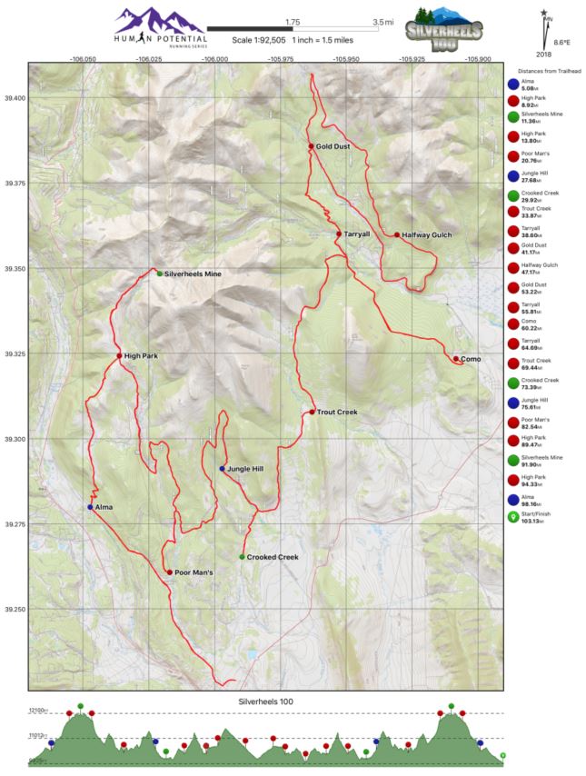
This was a great course. Essentially a long lollipop style course with a couple out & backs thrown in there. HPRS shared the detailed map, aid stations, and eve the .gpx course prior to the event for everyone. The course was very well marked (but not over marked 👍). Silverheels is a very tough challenge for everyone since it is known as the 2nd highest 100 miler within North America, behind only Hardrock 100. Silverheels comes in at an average elevation of 10,813' and let me tell you that it feels that way especially on the second half of the run (of course I am coming from sea level).
Detailed map and elevation profile provided by HPRS. Available on their website.

Nutrition

I stuck with mostly BASE Performance hydration mix and water (1 bottle of each). I supplement this with fit for the most part all the way up until about 70 mi mark. From there I started using GU Roctane gels one every 45 minutes or so to keep my energy up for the last quarter of the race (I think i went through about 6 of them total). I also downed Coca Cola every aid station for that quick sugar and caffeine hit. I think i also sat down and ate ramen noodles 2 separate times for the broth and warm fluids during the night hours.

Results & Data

Mileage: 105.70 mi (170.11 km)
Elevation Gain: 14,914' (4,554 m)
Total Time: 29:47:41
Place: 5th overall (4th male)
Silverheels 100 buckle and (x2) Silverheels mine summit bands

Gear Used


Thanks

  1. A big shout out to all my supporters and sponsors for this year - check out my Friends page.
  2. Human Potential Running Series (John Lacroix) for putting on this event and taking the new race protocols and social distancing seriously to make this event happen. I did feel quite safe out there.
  3. The volunteers! As always fellow ultrarunners and non-runners alike that help make these events happen deserve the majority of the credit. Thank you for assisting us runners and aiding us through the night on the mountain.
#staysafe everyone and remember to continue to social distance and follow your local guidelines. I know that some people may think me travelling at this time is not the best idea, and well I may tend to agree I put in all the mitigation measures possible to keep myself and my family safe. In the end I felt like I did everything I could. There is still a lot of people out there not wearing masks. 

----- ----- ----- ----- -----
Thank you for following along . 
This was ultramarathon #064 for me, and 16th 100 mile (or longer).  Next up: 
(i) Blazing 7s 100 mi Virtual Run (date: t.b.d. before Aug),
(ii) completing my #EverySingleStreet Sugar Land project
(iii) Trans-Texas Virtual Run 879 mi