My Western Time
2025 WSER | A Little Lottery & Waitlist (#37) Luck

WSER (race day)
Our 03:30 alarm goes and the blaring chimes awake myself and my wife in the small hotel room. Somehow the kids sort of stay sleep still until we start poking and prodding them to get up as we packed up the room and getting everyone down into the van for the short commute over to Palisades Tahoe. The drive was short as we managed a last minute hotel only like 5 Miles away within Tahoe City. The van was parked as we got there early enough for a decent spot close up and I headed in to check out the early morning vibes. The air was chilly (46f) as one expects in a mountain town! My Californian wife did not appreciate the “cool” air as much as I did. I wandered into a building right near the start line and discovered a long row of coffee pots the volunteers had set up for the run. I redeemed the super early morning wake up for my crew chief (i.e. wife) by bringing her a hot coffee back to the van. Finalizing my last minute checks, I eyed everything in my pack to ensure it was all there and in place. I was doing the race without drop bags so had to ensure I had everything on my person (i.e. my lighting system and batteries along with another layer of my choice). Nothing left to do but get excited now at this point. With about 25 minutes to race start the family all got out of the van this time and we headed near the start area where we did manage to find a small space in side to hang out within the large ever-growing crowd of runners, crew, and spectators.
 |
| (04:40) 20 minutes prior to Start with my daughters Palisades Tahoe, Olympic Valley | Photo: Katie Meding |
 |
| (04:53) Photo: Katie Meding |
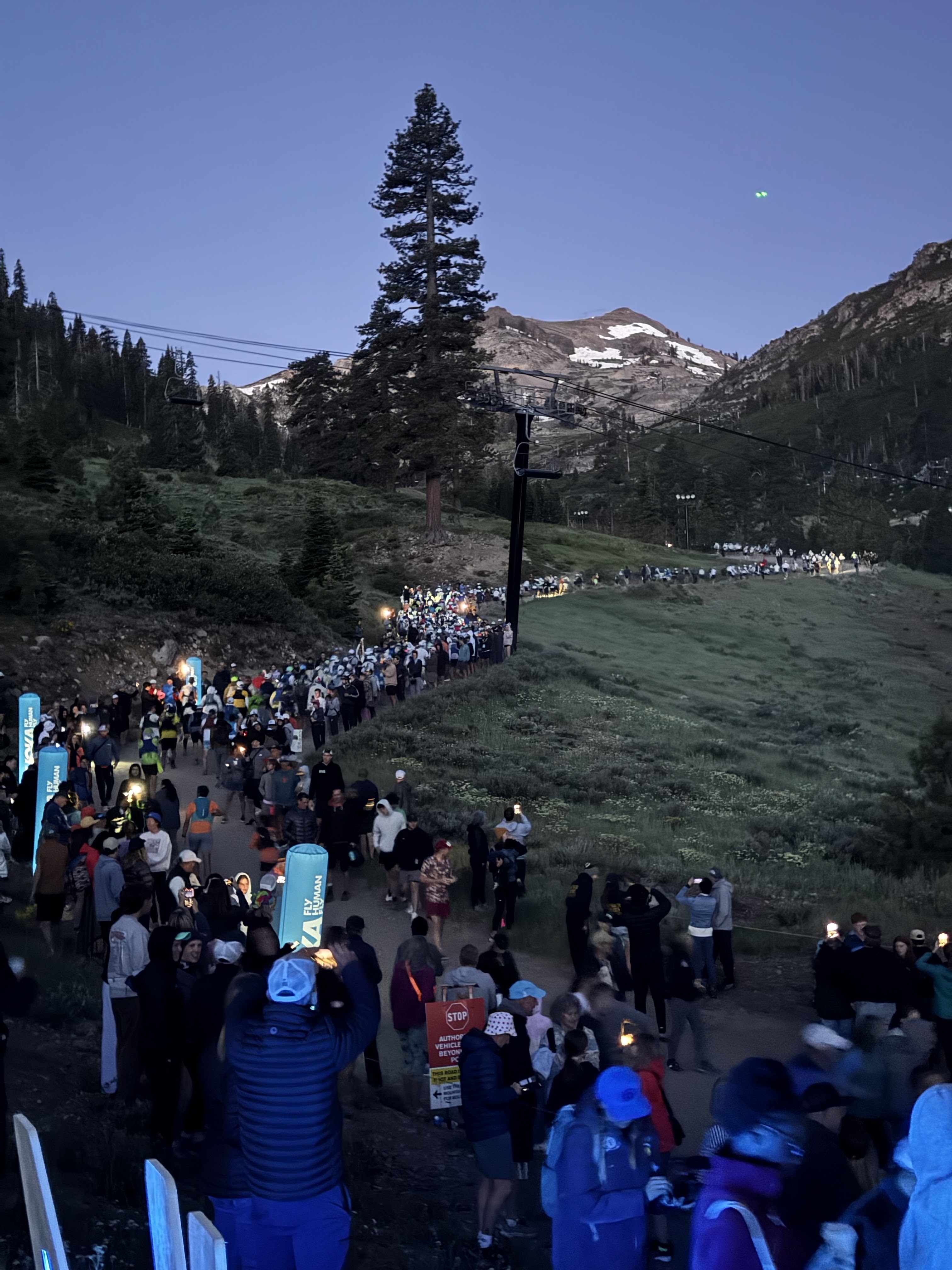 |
| (05:00) WSER Start up Escarpment. |
The climb up the Escarpment was basically a long hike celebration where I thought about my journey to WSER and just took in the ever expanding surrounding views as I got higher up the mountain. I was very happy to be there with everything else that had been going on in our lives lately. Ultrarunning can and truly is a form of calming meditation for me in a weird way (I know other ultramarathon junkies will understand that statement). As I got higher up there was more spectators whom had made the hike up to cheer people on. Passing under a chair lift there was a large group gathered there as it appeared to be the last false summit before the very top (right?…). Here I recognized and passed a couple people on the climb. Two of my fellow were rabbitELITEtrail teammates were there: Lauren Jones (@Lauren.runs.for.grilled.cheese) & Christopher Thomas (@burroslocos).
 |
| (05:48) Escarpment climb | Photo: Let’s Wander Productions | Esther Ramos |
I could sense the final summit with all my senses now tingling with the buzz in the air. People were screaming above. The sight of a huge group of spectators which seemed like a stadium of people standing on the rocks and forming a human-made single track up the final meters of the trail. Music was blaring and jams were pumping. The energy was intense and exciting. Another rabbitELITEtrail teammate, Adam Kimble (@adamkimble818) was there among the crowds too, although I did not spot him among the true insanity. Running through the tunnel of the screaming crowd made me feel like what I image a professional athlete in other sports might feel like in terms of reception sometimes. The entire gathering of people on the summit of the escarpment were yelling for every runner and this made it feel incredible. I got a huge number of high fives and a couple back slaps as I made the final crest of the mountain. WOW!
 |
| (05:55) summit crowds | Kevin Lara @kevinlaraphoto |
It was all downhill from here to Auburn, well mostly, as this initial climb is the highest point on the Western States course at 8,694 ft+ (Watson’s Monument) just ~3.7 Mi into the journey. I recall these numbers as I glanced at my watch at the top to note to myself. Over the summit and out of the human tunnel of the crowds the trail narrowed into a true singletrack down the other side and winding down into the alpine forest of the High Country. I fell into a mini congo-line of runners and got into the groove. The scenery was beautiful and this was my happy place. A few sparse running streams and a couple patches of wet muddy trail kept me alert onto my footing. The miles flew by as a just enjoyed every step out there. We arrived into the first aid station, Lyon Ridge, at 10.3 Mi just after emerging from the Granite Chief Wilderness section. At the aid I efficiently topped off my fluids and grabbed a couple pieces of fruit and kept going. Remembering back now I think the section here between Lyon Ridge and Red Star Ridge was my favorite section of the course. It was true ridge running and the views were vast and so picturesque in the morning sunlight.
 |
| (08:30) Red Star Ridge (15.8 Mi) | Photo: Let’s Wander Productions | Jesse Ellis |
The trail continued to flow through the high country and time was just flowing by as everything seemed easy thus far as I just was running easy and joyful. Next stop was Duncan Canyon at 24.4 Mi. I came down the trail into the aid station to a crowd of spectators cheering behind a ribboned off part of the aid station. A volunteer came directly up to me as I arrived into the aid and he said “Hi my name is ___, I am your runner handler for this stop”. (I recall this from listening to WSER podcasts and such but experiencing this type of volunteer service myself was cool, and took me back for a second). He took my bottles and went off to fill them for me with the fluids I had requested while I grabbed some GUs and fruit. Next he helped me put a few ice cubes into my rabbit ice hat as the heat was now starting to make itself known with the ever rising sun. I figured I better get onboard with the topical cooling now and stay ahead of things. I did not stay long here as the cheers gave me another boost of energy to continue running out on. I took off descending into the forest and onwards heading towards Robinson and what is known as the end of the High Country portion of the WSER course.
My #MedingCrew was another draw pulling me towards Robinson as well as the joy of the High Country miles. My family was planning on being there as their first stop as my support. I knew I was close to the mileage looking at my watch and then you would see a volunteer sitting there on the side of the trail taking your number and radioing back into the main aid station to prepare drop bags and simply warn them of whom was coming in. Again such volunteer organization and the structure of the way it seemed to function like a well-oiled machine was something to experience. The 3:1 (volunteer:runner) ratio is real and so unique from anything I have experienced thus far, in all my prior 125 ultramarathons to this point. The legends of WSER lore seemed to be true. With the ribbons and signs of the aid in sight I started looking for my kids and they saw and were cheering for me before I spotted them. My face lite up with a huge smile seeing all 5 of my young daughters there along with my wife supporting me on this journey. What a day couldn’t be better to share this with them. I handed off my bottles and got some food from the aid table before joining my family over on a nice flatfish rock they claimed as my chair. I got hugs and stories from all my kids as I took the time to take off my shoes and shake out some dirt and grit out of my socks and whatnot. Not crucial but again this was proactive part of trying to keep my feet in good order as there was still two thirds of the run ahead. A cold can of coke and melted popsicle was also on the menu. Spent a few minutes to chat with the family and enjoy the meet up before refilling my rabbit Ice RAD-dana and running onwards. At this point I was right on with the 24:00 hour WSER splits. So far so good.
 |
| (11:30) Crew stop at Robinson Flat (30.3 Mi) | Photo: unknown |
 |
| Enjoy first of many cold cokes out there. |
A short run downhill to Miller’s Defeat (34.4 Mi) for a water refill and downward to Dusty Corners (38.0 Mi). The trail system was now full more of double wide jeep forest roads and more of the “California carpet” smooth trails as we slowly lost elevation and now we getting below 6,000 ft+ and dropping making my way to the canyons. I was still feeling good and not getting too hot even though the ambient temperature was high. These miles between Robinson all the way to Last Chance (43.3 Mi) all seemed to blend together thinking back now. I seem to remember it as one section until I got into Last Chance. Running into the aid station here I saw another familiar face, rabbitELITEtrail teammate Mandie Holmes. She was there as a volunteer and tasked as one of the aid stations runner handlers. She saw me coming in and since we were “twinning” (both wearing our rabbit team kit) she came over and got my bottles and started to help me out. The heat was now noticeable even under the shade of the tall pines but I was not hot per say. As I got my ice refilled and sorted in my RAD-dana, Mandie filled me in and gave her advice and detailed where to get wet at the bottom of the canyon. I thanked Mandie as I headed out towards the first canyon of the infamous WSER middle canyon section. It was time to put my South Texas heat adaptation to the test.
 |
| Last Chance aid assist with teammate (43.3 Mi) | Photo: Mandie Holmes @runningmandie (https://www.instagram.com/p/ |
The descent leaving Last Chance was gentle at first and then bombed down steeply into the canyon towards the river at the bottom. I was passed by a couple runners on the way down but was going at good clip (for me). Once the river was in sight I noticed both runners in front of me take a side trail down to the water to get wet and soak in the river itself. I trusted Mandie’s recommendation and continued over the bridge and sure enough about quarter mile up the trail there was a tiny stream that formed a small “hot tub” sized pond right next to the trail. I dipped in here quick and ensuring to soak my RAD-dana and hat as my priority. It was only maybe 20 seconds or so but then I started up the other side of the canyon with just under 2 Miles to go until the top of Devil’s Thumb and the next aid. You hear people talk about this climb all the time in WSER podcasts and articles and so I knew this was going to be a grind, especially in the heat of the day and on the more exposed portions at the upper section. Up the countless switchbacks and switching between starring at my feet and taking the time to look around at the views that surrounded I made my way slowly up the steep Devil’s Thumb climb. I was slower than a lot of people and allowed multiple runners pass me on the way up. I did not let this bother me though and just kept moving forward albeit slow. Finally the sound of bells and yells were heard of runners being greeted into the aid station above me: I was close. I trudged into the aid station and found myself my first true chair sit of the day (beside the rock I used at Robinson). There was an awesome volunteer there whom came up to myself and another runner explaining how we can not sit too long. He was explaining how he had been part of the race since 1978. The guy was maybe in his 70s or so if I had to guesss and had a great attitude. Looking up at him after sipping my cold coke-cola I noticed he had a temper tattoo directly in the middle of his forehead. I squinted a bit and read it: “BEWARE OF THE CHAIR”. This dude is my kind of person, a true OG ultrarunner. I can only imagine how many people he managed to get out of the chair there at Devil’s Thumb over the course of his volunteer hours that day. After finishing off my coke and enjoying the banter about sitting I got up and started my way down the trail yet again. Onto the next canyon.
Another steep descent down into El Dorado Creek aid station (52.9 Mi) where it was located at the bottom. I topped up my fluids and had another coke (I think). This aid station is run by the WSER famous Tim Twietmeyer (5-time winner & 25-time finisher) which was pretty cool. I let this aid station and tackled the next climb up and out of this canyon heading to Michigan Bluff now. I was super excited to get there as this was the second planned crew stop for me where my family was scheduled to meet up with me. I did have a bit of a sore left foot now as my usual right heel blister started to flare up. I get the blister in the same spot every time when there is a lot of downhill running in 100s, something about the rubbing of the descents causes it flare up and I am at the point when I can detect this without ever taking off my shoes. So the second reason to get to the aid station was to also get this taken care of before heading into the second half of the run.
 |
| Kevin Lara @kevinlaraphoto |
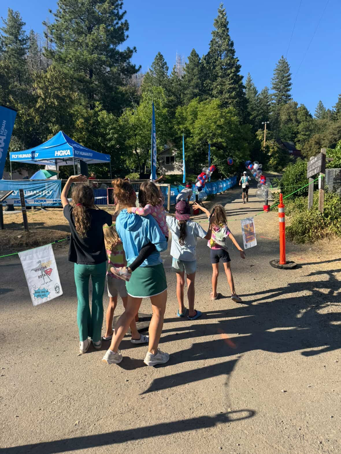 |
| (15:51) arriving into Michigan Bluff (55.7 Mi) Photo: Kelly Force @kelj99 - a former Sugar Land, TX resident whom recognized us |
Some foot care was the first order of business here at Michigan Bluff. My little crew members helped out by getting me some fluids and another cold coke-cola as I propped my feet up in the superb med tent setup. (We were told in the runner’s race brief this aid station is known for their foot care as most runners have issues here after the canyons and so they were all set up and ready). They fixed up my heel blister and also put a preventative padding on my left foot.
 |
| (18:07) foot care top notch pit crew at Michigan Bluff (55.7 Mi) | Photo: Katie Meding |
This stop was longer than expected but I got in some calories by eating some warm ramen soup and a few other things so my time was not fully wasted. Although my 24 hour pace time was slowly slipping its was still within reach at this point. My daughters were all excited to see me and were sharing their fun parts of their day(s) so far. I enjoyed the banter and it provided huge amount of positive energy. I thanked Katie again so being there and being such a huge support as I headed off for the next 10 km until I would see them again one last time before nightfall. This section was a fast runners dream of a mix of dirt and paved roads all the way into Foresthill. Sadly I was not a fast runner at this point into my day but I kept the forward momentum. I remember the last long road climb uphill past a welcoming sign into Foresthill as the edge of the town emerged. I recognized the trail running beside the road from the prior years WSER livestreams, so I knew I was super close. Many people were out in their chairs and sitting by their cars cheering on runners as we ran by down to the aid station. The Western States vibes were still out in full force for us mid-packers which was cool to experience 100 km into the run. I passed through the actual checkpoint of the aid station and my two oldest kids were there on the far side awaiting me. I did not need any more solid food at this point so I followed them over to a bench where the rest of my family was waiting. I sat down again and greeted everyone just simply being glad to be there and sharing this moment with them. They all seemed stoked as well it was late in the day (recall we all got up prior to 04:00 this morning).
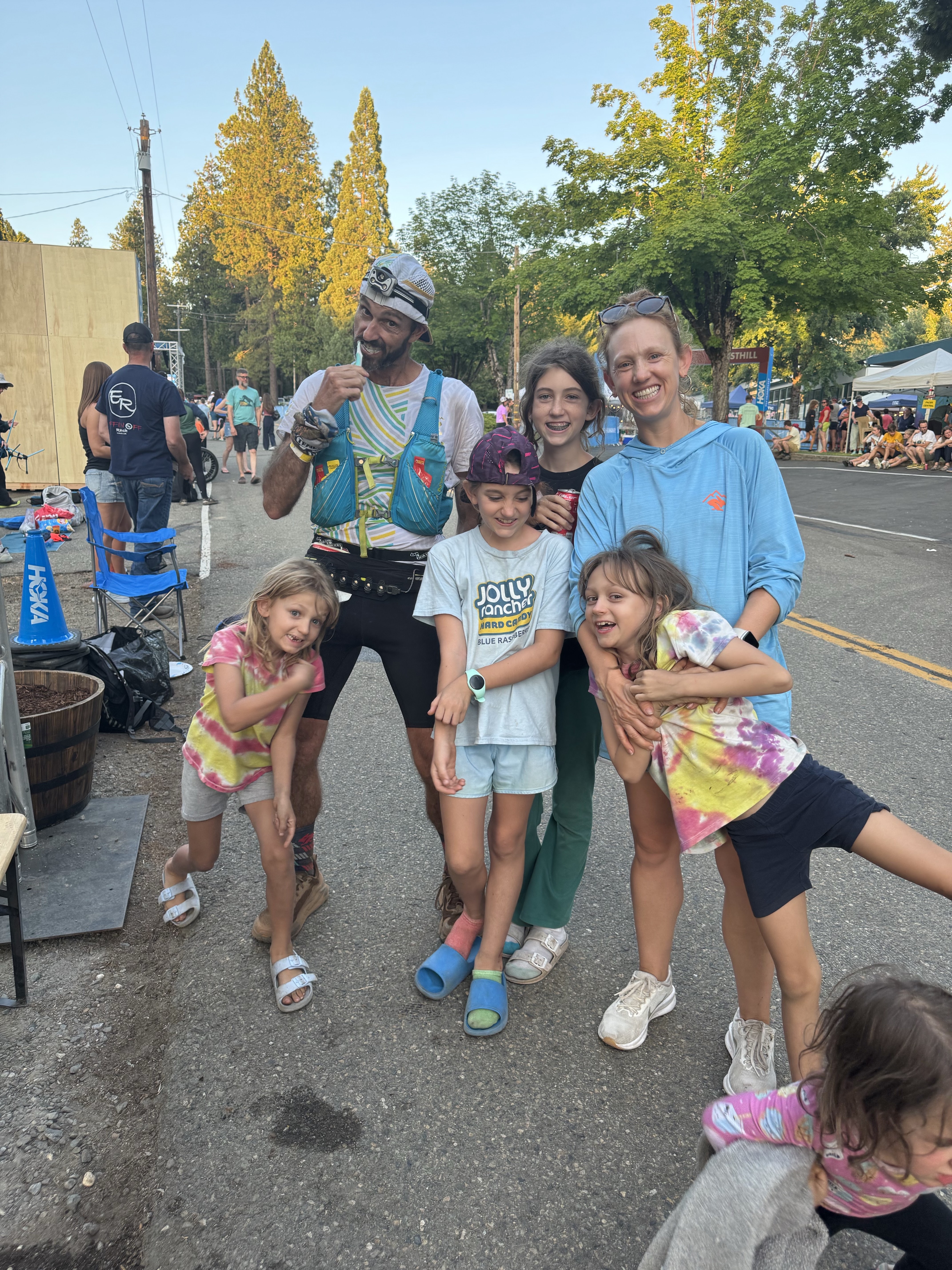 |
(20:01) brushing my teeth, chatting with kids, hanging with family at Foresthill (62.0 Mi) Photo: unknown |
The canyons and the daylight was now behind me. I dawned my kogalla waistlamp and Nathan headlight and got ready for the infamous runnable “Cal-street” section. My quads were pulsating at this point after I stood back up but the energy I received from my family overcame that feeling. I gave all my girls hugs and kisses goodnight and told them all I could not wait to see them in the morning at Auburn.
Running out of Foresthill I followed the WSER signage through the rest of town and to the trails. The California carpet of Cal-street was here, but could I run this downhill section(s). I tried to keep a descent pace where my quads would not feel like exploding. The first 3.5 Mi to Cal-1 (Dardanelles 65.7 Mi) flew by as the trail winded downhill and along the hillside. The sun had fully faded behind the mountains now. Then something slipped at the aid station as I left. Cal-1. No real reason of explanation but not far out of aid station I started walking and was unable to run. What happened? Why was this bonk occurring now after feeling completely fine moments ago? What is going on? I had tried to run but my legs would not cooperate. I struggled the entire 5.0 Mi section and basically zombie walked it to Cal-2 (Peachstone 70.7 Mi). I sat down here at the small aid station and downed another energizing coke along with other fluids. Grabbed a few more GU gels to go and after feeling slightly better I took off with the anticipation of getting to the river. First up was the remainder of Cal-street and getting past Cal-3 (Ford’s Bar 73.0 Mi) with another 5 Miles to get to the Rucky Chucky river crossing. I was still not moving super well, but at least now I was running/jogging again moving past my bonk stage. Sadly I knew this had cost me any chances of my 24 hour chances but that did not matter in the overall scheme of things. I must get to the river and hope that would give my legs the boost I needed to finish this race off. Running along the river I could start to hear and eventually see the lighting of the river crossing. I climbed unto the near side aid station (Rucky Chucky River Crossing 78.0 Mi) but simply walked right through since I knew the far side was close by after a climb. I ran down to the river and the literal army of volunteers here in the middle of the night whom were all there to help us safely across the river. The water was cold and very refreshing. I had taken my waistlamp off and placed it around my neck just to keep my battery out of the water. I held onto the rope strung out and slowly traversed the rocky river bottom following the directions of the volunteers who were placed every 15 to 30 feet along the rope (they literally stood in the cold mountain water just waiting for runners - what a volunteer position!). Since I was crossing here in the wee hours of the night the crossing also had placed small glow sticks into the bottom of the river which you could see through the clear water and it helped “see” the large boulders and rocks to step over and where to aim your foot placement so you would not fully topple over by mistake while fording the river. I got the far side of the river and dipped my hat back in one last time getting a nice douse of cold water for over my head. The Rucky Chucky river crossing was a cool experience mid race as it did get to chest deep on me, which is about 4’10” give-or-take. After climbing the sandy river bank (optional fixed rope assist) I got up onto solid ground again and there was a drop bag station there where lots of runners were there changing socks and shoes. I kept going as I was not using any drop bags for this run (I did wish I had brought a pair of socks though in my pack - oh well next time). I continued on the gradual climb all the way up to the actual aid station Green Gate (79.8 Mi). At the aid station itself Regina Massingill was there to greet me. A fellow HATR (Houston Area Trail Runners) whom had been volunteering at the aid station all day supporting runners. Now she was hanging out and cheering on fellow Texas runners she knew headed her way. We chatted for a brief moment before taking off.
 |
| Green Gate (79.8 Mi) | Photo: Regina Massingill @reginarunshouston (https://www.instagram.com/p/ |
Another 5-ish Mile section took me to the next aid station of ALT (Auburn Lake Trails 85.2 Mi). I recall thinking that the end is near when the aid station start having names of Auburn in their title. My goal now was to keep moving forward and keep the sleepies away. Yet another 5-ish Miles got me to the Quarry Rd (90.7 Mi) aid station that was famous for being manned by Hal Koerner and Scott Jurek. I came running down the steep hill into their aid station being called by the loud blaring music being played. One of the volunteers said I was one of the few to actually run down into the aid, which made me feel good, even it was not true, but I wanted to believe them at that point. A mere 10 miles to go, lets get this done. I did not stay long here and ran out chasing day the sunset towards Pointed Rocks (94.3 Mi). I don’t recall seeing any runners at all in these last 10-15 miles so most of these miles were solo just me in my head dreaming of the finish line.
With glimpses of first light now I came into Pointed Rocks greeted by one of the volunteers live-streaming for the YouTube broadcast. I did not sit down but simply got a little more fruit and GUs (caffeinated) to go to get me through. Less than 10 km to go now! Next up in my head was the iconic no Hands Bridge and the final Robie Point to Placer High street run. I knew well of these from the prior years broadcasts. After what seemed like a long descent along the river I finally did get down to the No Hands Bridge and crossed the North Fork American River. A short flat section of trail after the bridge before making the final steep climb up to Robie Point and what is the final check point. Seeing the flags of the aid station was a huge relief as I knew only just over a mile through Auburn to the track to go! I had done it.
Now my focus was on keeping my eye for my second daughter, Lily, whom said she was ready to run the last Mile in with me. At Western States your entire crew/family/support are all aloud to run with you on the streets from Robie Point to the finish if desired, and well Lily had been psyched herself up to be able to run a mile with me. I assured her there was no issue at the pace I’d be going at that point in time. Filled my bottles with water as it was slowly warming up again after the second sunrise well into Sunday morning now. I left Robie and was starring at my watch counting down the tenth of miles. I saw a familiar face ahead on the road. Again it was Regina who came out to the finish to see me in. She came up to me, still in he Buc’ees onesie and jogged along side of me grabbing some pictures and video. She asked me how I was doing and congratulating me on the finish. About a half mile to go now. Then ahead I hear my daughter Lily yell “DAD” and saw her bolt toward me up the slightly grade hill in front of her. I reached out and gave her a big hug. She said they were waiting for me and the rest of the family was just ahead outside the track waiting for me. So I looked at her and as promised I asked her if she was ready to run. She nodded and took off towards Placer High and I followed along side of her. Right then we were also greeted by the livestream team and a follow cam to capture the last portion of my run into the finish. The volunteer ran beside Lily & I capturing us running down the street together as I struggled to keep pace with my 8 year old full of energy, but man what a feeling. Rounded the next corner and there was a bunch more screams and cheers as I saw my other 4 daughters and wife waiting for me just outside the entrance to the track. Everyone came in for a group hug and I continued forward onto the track with all my family now running with me. Zoey our youngest daughter wanted to run so we slowed down to a 3 year old pace as we got onto the track surface itself and made our way the 300 m around to the finishing arch. The growing morning crowds were cheering and yelling, I was smiling, my kids were all running, jumping, and dancing around me as we rounded the last turn. We made it to the finish and crossed in 26:13:15 official time running all-together in a family line. What a feeling to have them all there and all of them run with me to share in this experience. I had dreamt about finishing Western States one day and sharing the moments with my family and there was no better way to do so than finishing hand-in-hand. Perhaps recently bias but this has to be one of my most favorite memories in ultrarunning to date, if not the top one. Greeted by a few WSER long-time volunteers as well as WSER board member Magdalena Boulet whom presented me with my finisher medal and a congratulatory hug. I just stood there with a smile for a second then another volunteer immediately gathered us underneath the finish arch for a family group picture and then ushered us out of the way. I walked to the end of the track where a person was gathering foot scans with permission for a book project. I said yes and volunteered my feet for the cause which only took a couple minutes.
 |
| (07:09) family meeting me outside Placer HS track | Photo: Katie Meding |
 |
| (07:11) on track with kids | Photo: Katie Meding |
 |
| (07:12) WSER finish | Photo: Let’s Wander Productions | Jesse Ellis |
 |
| (07:12) WSER finish | Photo: Let’s Wander Productions | Jesse Ellis |
 |
| #MedingCrew | 26:13:15 WSER Complete (100.2 Mi) | Photo: unknown |
 |
| (07:19) scanning my feet at finish | Placer High School Track (100.2 Mi) Photo: Let’s Wander Productions | Jesse Ellis |
 |
| WSER journey from Palisades Tahoe in Olympic Valley to Placer High School in Auburn, CA complete. |
Results & Stats.
- 26:13:15 | 100.59 Mi (161.89 km) | 17,388 ft+ (5,300 m+)
- 129th overall | M104
- This was my 125th ultramarathon run total & 4th of 2025.
- My 46th 100Mi(+) completed.
- STRAVA: Western States Endurance Run (127th overall), Palisades Tahoe, Olympic Valley, CA
- UltraSignup Results: 2025 Western States Results
- YouTube Live Broadcast: @WesternStates/streams
Gear Used
- Lighting setup: kogalla RA Adventure Light (waistlamp) & Nathan Halo Fire (headlamp)
- SS Shirt: rabbitELITEtrail team kit
- Shorts: rabbit Speedsters rabbitELITEtrail kit
- Headwear: rabbit/BOCO rabbitELITEtrail kit (Ice Hat)
- Other: rabbit Ice RAD-dana
- Eyewear: Tifosi Optics
- Socks: injinji x1 & rnnr x1
- Shoes: Altra Olympus 6.0
- Hydration: Nathan Trailmix 12L race pack with x2 20oz soft flasks.
- Watch: Garmin fēnix® 6X - Pro Solar Edition
- Anti-Friction Lube: Squirrels Nut Butter (applied once pre race).
 |
| Huge shout out to rabbit for the continued support & amazing apparel #rabbitELITEtrail |
Reflections on the Western States Hype Machine
1. Looking back now two weeks removed from my finish as I finalize my race recap here I realize how special the race was. The course, yeah its cool being a point-to-point run incorporating mountains and canyons and some fast California trails, but honestly I’ve run some cooler better actual courses. The historical importance of the race and the vibes that surround Western States I think are what helps build and maintain the race atmosphere out there for runners. The fact that there is the Trail Con in the week leading unto WSER now and the gather of many elite and PRO runners whether they are running or crewing and supporting their teammates it provides a great gathering of the ultra community all in one place at Olympic Valley in the lead up to the start of Western States. Daily podcasts and interviews from the media outlets (e.g. Freetrail, Mountain Outpost, and Singletrack) have given this event in particular the lure of a “major” event type feel akin to a major in say golf or tennis where there is only a handful a year. Ultrarunning is trending that way in which our majors could arguably include WSER, HR100, and UTMB.
2. The historical aspect of Western States being the oldest organized hundred miler within the United States makes this stand out as well. It is brought up every year and the historical data and comparisons make for great storylines every year.
3. I think that the fact that the amount of interest in this particular event just to get into provides a very unique aspect of the Western States. Being a guaranteed sold out lottery and now the average is trending towards 5-6 years in the lottery system makes this a literal 1, maybe 2 time, event for people in a lifetime. Just look at the stats on their lottery website and you can see how hard and statically stacked it is against you until you have say 5 years in the lottery as of the current way the system works. It may seem unfair but with the amount the sport of ultrarunning is growing and the interest in WSER as it grows it’s own importance in the sport I forsee this trend continuing as long as the permits maintain the current runner cap limit. Essentially if you are lucky enough to get into Western States my advice is just to soak it in and enjoy the entire journey from Palisades Tahoe, Olympic Valley all the way to Placer High School track in Auburn, CA. Sure have your goals and time splits, but just take what the day gives you and simply be grateful we get to do this crazy sport.
4. Volunteers and the community that surround this race does elevate the runner experience. One example of this is the bibs. They simply print your race number and then in large bold letters is also just your first name. This is done on purpose for everyone including spectators and volunteers to easily see your name and address you personally whether it is from the crowd our at the aid station when getting assistance. It is a small but personal detail that gives WSER that one more level up in terms of race experience. Secondly, I think I mentioned this above, but the 3:1 ratio of volunteers is a known statistic that WSER prides itself on and that truly does feel amazing and awesome when coming into aid stations when immediately you have someone personally taking care our your bottles and anything else you may need right away. I have yet to be involved in another race that has anywhere near this level of total volunteer enthusiasm. The fact that you need to apply to volunteer at most of the aid stations shows the commitment to the WSER race and community. Thank you to all of you volunteers out there helping me find my way to Auburn here in June of 2025. You guys & gals all rock!
5. Western States is known for a couple things and heat is one of them. Almost every year it is in the 90s on average and thus some sort of heat training or at least cooling strategy is required in order for the runners to complete and have a decent day for them out there. That being said I did not find the Western States here in 2025 to be an issue at all. (Now let me caveat this based on a couple things). So this year was an above average temperature being in the mid 90s on race day, but overall I did not find the California heat to be as intense and the Southern Texas humidity heat I had been dealing with in May and June. Also I had used ice with my rabbit Ice Hat and rabbit RAD-dana every since early morning to initial that topical body cooling as a preventative measure. I think the combination of the Texas heat adaptation and topical cooling let me to not really feeling or worrying about the heat too much on race day. I did find myself attempting to quench my never-ending thirst but never felt dehydrated out there, which was also good. Overall you just need to understand heat and your own heat adaptation coming into this race because many people do struggle with it out there. The canyon rocks did feel hot, but I’ve experienced worse so perhaps I just not let it get in my head at all.
My final advice is simple. Keep doing your WS Qualifiers. Pursue the lottery every year and build that ticket count. Eventually you will get in, even if it takes the better part of a decade. From my one-time WSER experience having never been there at all prior to getting the full on runner experience I highly recommend you keep it on the bucket list as a to-do 100 Miler within the USA.
For 2026 I got myself some UTMB running stones (4 in fact) and my WSER qualifier (back to 1 ticket). Now I can enter both lotteries for 2026 editions. Who knows perhaps it does not take me 6 more years to get back to Western, but on the other hand perhaps it takes longer...

----- ----- ----- ----- -----
.jpg)


.jpg)

.jpg)


.jpg)


.jpeg)
.jpg)
